1970s Maps of Midpine, North Carolina
Explore 2 historic maps of Midpine from the 1970s. These maps offer a rare glimpse into what life looked like during the 1970s — showing old roads, neighborhoods, homes, and landmarks that have changed or disappeared over time.
Whether you're researching your family's past, planning a metal detecting trip, or studying how Midpine's landscape evolved across the 1970s, these high-resolution maps are a powerful tool for exploring the history of this region.
- Focus on a specific era: All maps on this page are from the 1970s, giving you a focused view of this time period.
- See what’s changed: Compare century-old streets, trails, and buildings to today's modern landscape using overlays and satellite layers.
- Research with precision: Use these maps for genealogy, historical research, land use analysis, or educational projects.
- View, download, or print: Maps are fully viewable online in high resolution, and can be downloaded or printed for your own records.
Start exploring Midpine's history through authentic maps from the 1970s. This is your window into the past.
Midpine, NC maps
(2)- 1971 Map of Grover, 1974 Print
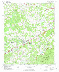 1971 Grover1974 Print · USGSStraddling the Carolina state line in the early seventies, this region features a landscape of small rail-side settlements and rolling foothills. Genealogists and local historians can locate numerous country churches like St Peters Ch and Bethlehem Ch, as well as the Grover Cem.2 unique versions available
 - 1976 Map of Grover, 1978 Print
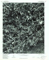 1976 Grover1978 Print · USGSGrover and the surrounding Carolina borderlands are captured from above in the mid-1970s, showing the intersection of rural life and highway growth. Researchers can trace the development of Grover and Mudpine or follow the path of Buffalo Creek.
End of results
Showing maps 1-2 of 2
Top cities near Midpine
- Gastonia historical maps
- Shelby historical maps
- Gaffney historical maps
- Kings Mountain historical maps
- York historical maps
- Cherryville historical maps
See more
Frequently asked questions
- What are the different types of historical maps available for Midpine?
- What is the oldest map of Midpine?
- Where can I purchase historical maps of Midpine for my home or office?
- Where can I download high-res historical maps of Midpine?
- Are there historical topographic maps available for Midpine?
- Is there historical aerial imagery available for Midpine?
- Where are historical maps of Midpine sourced from?