1940s Maps of New Bern, North Carolina
Explore 3 historic maps of New Bern from the 1940s. These maps offer a rare glimpse into what life looked like during the 1940s — showing old roads, neighborhoods, homes, and landmarks that have changed or disappeared over time.
Whether you're researching your family's past, planning a metal detecting trip, or studying how New Bern's landscape evolved across the 1940s, these high-resolution maps are a powerful tool for exploring the history of this region.
- Focus on a specific era: All maps on this page are from the 1940s, giving you a focused view of this time period.
- See what’s changed: Compare century-old streets, trails, and buildings to today's modern landscape using overlays and satellite layers.
- Research with precision: Use these maps for genealogy, historical research, land use analysis, or educational projects.
- View, download, or print: Maps are fully viewable online in high resolution, and can be downloaded or printed for your own records.
Start exploring New Bern's history through authentic maps from the 1940s. This is your window into the past.
New Bern, NC maps
(3)- 1942 Map of Maysville
 1942 Maysville1942 Print · USGSCoastal North Carolina during the early years of the war is captured here through its networks of swamp forests and river settlements. Genealogists and local historians can trace the rural landscape through White Oak Sch, the Hadnot Ch, and rail stops along the Atlantic Coast Line Railroad.
 - 1948 Map of Maysville
 1948 Maysville1948 Print · USGSCoastal North Carolina's river-fed lowlands come to life in this late-forties survey of the Jones and Onslow county borderlands. Genealogists and local historians can trace the rural landscape from Polloksville down to Stella, locating landmarks like Tabernacle Sch and Lees Ch.
 - 1949 Map of Havelock, 1952 Print
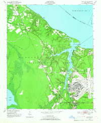 1949 Havelock1952 Print · USGSCoastal North Carolina at the dawn of the fifties shows a landscape of deep pine forests and growing military infrastructure. Researchers can trace the early layout of the Cherry Point Air Station and locate local landmarks like Brice Creek Ch and the Croatan Lookout Tower.4 unique versions available
End of results
Showing maps 1-3 of 3
Top cities near New Bern
- Havelock historical maps
- James City historical maps
- Trent Woods historical maps
- Brices Creek historical maps
- River Bend historical maps
- Fairfield Harbour historical maps
See more
Top neighborhoods of New Bern
- Craven Terrace historical maps
- Southgate historical maps
- Washington Forks historical maps
- Chelsea Square historical maps
- Colony Estates historical maps
- Cypress Shores historical maps
See more
Frequently asked questions
- What are the different types of historical maps available for New Bern?
- What is the oldest map of New Bern?
- Where can I purchase historical maps of New Bern for my home or office?
- Where can I download high-res historical maps of New Bern?
- Are there historical topographic maps available for New Bern?
- Is there historical aerial imagery available for New Bern?
- Where are historical maps of New Bern sourced from?