1980s Maps of Cumberland County, North Carolina
Explore 13 historic maps of Cumberland County from the 1980s. These maps offer a rare glimpse into what life looked like during the 1980s — showing old roads, neighborhoods, homes, and landmarks that have changed or disappeared over time.
Whether you're researching your family's past, planning a metal detecting trip, or studying how Cumberland County's landscape evolved across the 1980s, these high-resolution maps are a powerful tool for exploring the history of this region.
- Focus on a specific era: All maps on this page are from the 1980s, giving you a focused view of this time period.
- See what’s changed: Compare century-old streets, trails, and buildings to today's modern landscape using overlays and satellite layers.
- Research with precision: Use these maps for genealogy, historical research, land use analysis, or educational projects.
- View, download, or print: Maps are fully viewable online in high resolution, and can be downloaded or printed for your own records.
Start exploring Cumberland County's history through authentic maps from the 1980s. This is your window into the past.
Cumberland County, NC maps
(13)- 1982 Map of Elizabethtown, 1983 Print
 1982 Elizabethtown1983 Print · USGSSoutheastern North Carolina's coastal plain is captured here in the early eighties, showcasing a landscape defined by the Cape Fear River and mysterious Carolina Bays. Genealogists and researchers can trace the rail network of the Seaboard Coast Line through rural communities like Autryville, Ivanhoe, and the recreational hub of White Lake.
 - 1982 Map of Southern Pines, 1983 Print
 1982 Southern Pines1983 Print · USGSCentral North Carolina in the early eighties shows a landscape defined by military expansion and historic rail corridors. Researchers can trace the legacy of the Seaboard Coast Line through Pinehurst or locate landmarks like the Town Creek Indian Mound State Historic Site.
 - 1983 Map of Laurinburg, 1984 Print
 1983 Laurinburg1984 Print · USGSThe Carolina borderlands come into focus in the early 1980s, showcasing a landscape defined by the Sandhills Game Land and major river systems. Genealogists and rail historians can trace the paths of the Seaboard Coast Line Railroad through Hamlet or locate St Andrews College and Cheraw State Park.2 unique versions available
 - 1986 Map of Garland
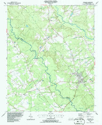 1986 Garland1986 Print · USGSSampson and Bladen counties in the mid-1980s are defined by the convergence of the South River and several distinctive Carolina Bays. Researchers can trace rural community centers through old landmarks like Smith Chapel, Antioch Ch, and Parkersburg.
 - 1986 Map of Fayetteville
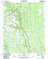
 1986 Fayetteville1986 Print · USGSThe North Carolina coastal plain appears in the mid-1980s as a bustling corridor of military installations and historic tobacco towns. Genealogists and historians can trace the footprints of Fort Bragg Military Reservation, Campbell University, and the rail lines of the Seaboard Coast Line RR.2 unique versions available
 - 1986 Map of Hope Mills, 1987 Print
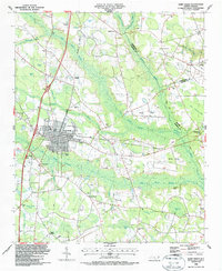
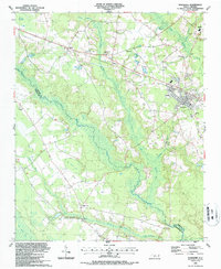
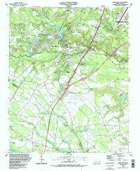 1986 Hope Mills1987 Print · USGSCumberland County saw significant suburban and industrial transition in the mid-eighties as modern infrastructure met older rural foundations. You can trace family roots at Adcox Cem, locate the former Old Railroad Grade, or study community hubs like Hope Mills Lake and Stony Point Ch.2 unique versions available
 - 1986 Map of Duart, 1987 Print
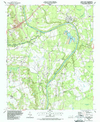
 1986 Duart1987 Print · USGSCoastal plain settlements near the Cape Fear River are captured here in the mid-1980s, showcasing a landscape of managed waterways and rural crossroads. Researchers can locate local landmarks like Millars Chapel, the William O Huske Lock and Dam No 3, and family burial grounds such as Wills Creek Cem.
 - 1986 Map of Cedar Creek, 1987 Print
 1986 Cedar Creek1987 Print · USGSCumberland County south of Fayetteville shows a landscape of river-bend industry and rural communities in the 1980s. Researchers can locate local landmarks like Mt Calvary Ch, Seabrook Sch, and the numerous Sandpit sites along the Cape Fear River.
 - 1986 Map of Saint Pauls, 1987 Print
 1986 Saint Pauls1987 Print · USGSRobeson and Cumberland counties meet in this mid-eighties survey during a time of steady rural development and rail transit. Researchers can find numerous family landmarks and churches, from McMillan Cem and Fisher Cem to Solid Rock Ch and the settlement at Tobermory.
 - 1987 Map of Ammon
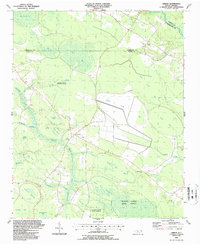 1987 Ammon1987 Print · USGSCoastal plains and pocosin wetlands define this portion of Bladen County in the late eighties. Researchers can trace rural lineages through numerous local sites like Ammon, Windsor Ch, and the many family-named depressions like Cain Bay.
 - 1987 Map of Autryville
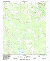 1987 Autryville1987 Print · USGSSettled along the South River in the late eighties, the area around Autryville maintains its rural rail-and-timber character. Researchers can trace historic church sites like St Johns Ch and Union Hill Ch or explore the unique geography of Bushy Lake.
 - 1987 Map of Jerome
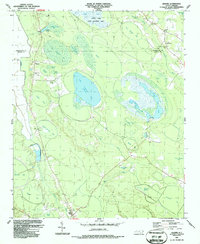 1987 Jerome1987 Print · USGSCoastal plain wetlands and the unique Carolina Bays characterize the Bladen County interior in the late eighties. Researchers can trace rural settlement patterns near Jerome and White Oak, locating historic congregations at China Grove Ch and Dove Chapel.
 - 1987 Map of Roseboro
 1987 Roseboro1987 Print · USGSRoseboro and the surrounding Sampson County swamplands are captured here in the late twentieth century, showing a landscape defined by the South River. Researchers can locate numerous rural landmarks like Beaver Dam Sch, Mill Creek Ch, and an Old Railroad Grade.
End of results
Showing maps 1-13 of 13
Top cities of Cumberland County
- Fayetteville historical maps
- Hope Mills historical maps
- Spring Lake historical maps
- Stedman historical maps
- Wade historical maps
- Falcon historical maps
See more
Frequently asked questions
- What are the different types of historical maps available for Cumberland County?
- What is the oldest map of Cumberland County?
- Where can I purchase historical maps of Cumberland County for my home or office?
- Where can I download high-res historical maps of Cumberland County?
- Are there historical topographic maps available for Cumberland County?
- Is there historical aerial imagery available for Cumberland County?
- Where are historical maps of Cumberland County sourced from?