1980s Maps of Currituck County, North Carolina
Explore 17 historic maps of Currituck County from the 1980s. These maps offer a rare glimpse into what life looked like during the 1980s — showing old roads, neighborhoods, homes, and landmarks that have changed or disappeared over time.
Whether you're researching your family's past, planning a metal detecting trip, or studying how Currituck County's landscape evolved across the 1980s, these high-resolution maps are a powerful tool for exploring the history of this region.
- Focus on a specific era: All maps on this page are from the 1980s, giving you a focused view of this time period.
- See what’s changed: Compare century-old streets, trails, and buildings to today's modern landscape using overlays and satellite layers.
- Research with precision: Use these maps for genealogy, historical research, land use analysis, or educational projects.
- View, download, or print: Maps are fully viewable online in high resolution, and can be downloaded or printed for your own records.
Start exploring Currituck County's history through authentic maps from the 1980s. This is your window into the past.
Currituck County, NC maps
(17)- 1982 Map of South Mills
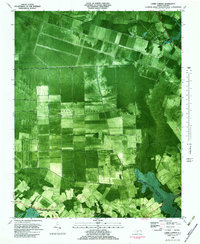
 1982 South Mills1982 Print · USGSThe Great Dismal Swamp and its historic canal network define this coastal North Carolina landscape in the early eighties. Researchers can trace rural lineages through sites like Morgans Corners, Trinity Ch, and the Memory Gardens Cemetery.
 - 1982 Map of Shiloh, 1983 Print
 1982 Shiloh1983 Print · USGSCamden County's river-dependent landscape is documented in the early eighties as agriculture and the tidal wetlands met along the Pasquotank. Genealogists can locate family burial plots and community landmarks like New Shiloh Ch, Smiths Corner, and the Belcross Lookout Tower.
 - 1982 Map of Currituck, 1983 Print
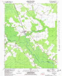
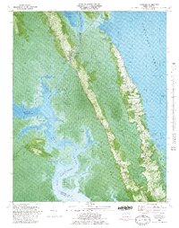
 1982 Currituck1983 Print · USGSCoastal North Carolina's transition from swamp to shore is captured here in the early eighties, documenting the railroad corridors and maritime routes of the Outer Banks region. Researchers can trace family sites near Shawboro and Sligo, or locate historic maritime landmarks like the Knotts Island Ferry and Plymoor Mem Ch.2 unique versions available
 - 1982 Map of Elizabeth City, 1983 Print
 1982 Elizabeth City1983 Print · USGSElizabeth City and its surroundings are captured in the early 1980s during a period of steady growth along the Pasquotank River. Genealogists and historians can trace the foundations of Elizabeth City State University, the U S Coast Guard Air Base, and community landmarks like Sawyers Creek Ch.2 unique versions available
 - 1982 Map of Lambs Corner, 1983 Print
 1982 Lambs Corner1983 Print · USGSCamden and Currituck counties appear in the early 1980s as a landscape of managed wetlands and rural rail hubs. Researchers can trace the drainage of the Great Dismal Swamp via the Guiena Mill Run Canal or locate families near Gregory and Lambs Corner.
 - 1982 Map of Barco, 1983 Print
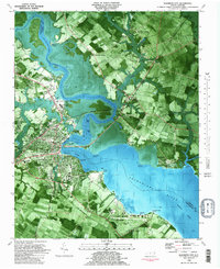
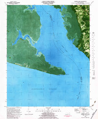
 1982 Barco1983 Print · USGSThe Outer Banks and Currituck Sound are seen here in the early eighties, defined by maritime life and marshy refuges. Trace family-named sites like Knotts Landing, the Knotts Island Ferry, and old country churches like Great Hope Ch.2 unique versions available
 - 1982 Map of Jarvisburg, 1983 Print
 1982 Jarvisburg1983 Print · USGSThe Currituck Banks and mainland neck are captured in the early eighties as coastal development began to accelerate. Genealogists and researchers can locate numerous community landmarks, from Hebron Ch to the small settlements of Olds and Mamie.
 - 1982 Map of Point Harbor, 1983 Print
 1982 Point Harbor1983 Print · USGSThe Currituck peninsula at the start of the eighties is captured here at the junction of two sounds. Trace local family history through community clusters at Harbinger and Spot, or locate landmarks like Hog Quarter Landing.
 - 1982 Map of Martin Point, 1983 Print
 1982 Martin Point1983 Print · USGSThe Outer Banks barrier islands are seen here in the early eighties as residential development began to reshape the coastline. Genealogists and historians can trace the footprints of Southern Shores and Duck, or locate landmarks like the local Fire House and Jean Guite Cr.
 - 1982 Map of Coinjock, 1983 Print
 1982 Coinjock1983 Print · USGSCoastal Currituck County in the early eighties is defined by its maritime heritage and the winding path of the Intracoastal Waterway. Researchers can trace local lineage through numerous family burial sites and landmarks like Center Chapel, Griggs Sch, and the community of Aydlett.
 - 1982 Map of Camden Point, 1983 Print
 1982 Camden Point1983 Print · USGSThe North Carolina coast in the early eighties reveals a landscape of marshy points and maritime corridors. Researchers can trace local landmarks like Walnut Island, find family burial sites marked as Cem, and see the path of the Intracoastal Waterway.
 - 1982 Map of Mossey Islands, 1983 Print
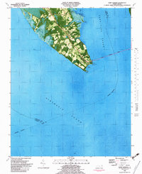
 1982 Mossey Islands1983 Print · USGSThe North Carolina Outer Banks are captured in the early eighties as a complex network of marshes and migrating dunes. Genealogists and historians can trace the remote landscape of the Pine Island Club, Peters Quarter, and the waterfowl ponds around Swan Island.
 - 1982 Map of Corolla, 1983 Print
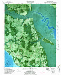
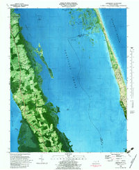
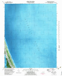
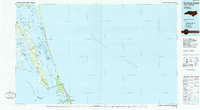
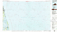
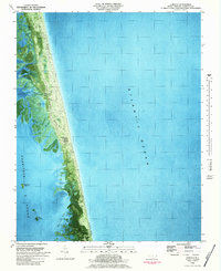 1982 Corolla1983 Print · USGSThe Outer Banks of Currituck County appear in this early 1980s orthophotomap as a delicate thread between the sea and the sound. Local historians can trace the foundations of Corolla and the prominent Currituck Beach Lighthouse amidst the marshy reaches of Raccoon Bay.2 unique versions available
 - 1985 Map of Currituck Sound
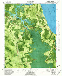
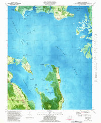
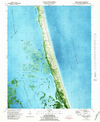
 1985 Currituck Sound1985 Print · USGSThe Outer Banks and Currituck Sound are documented in the mid-1980s, during a period of steady coastal growth and preservation. Researchers can locate long-standing maritime landmarks like the Currituck Beach Lighthouse and trace the original footprints of settlements from Corolla to Kitty Hawk.2 unique versions available
 - 1985 Map of Virginia Beach
 1985 Virginia Beach1985 Print · USGSThe Virginia and North Carolina coastline in the mid-eighties shows a landscape of strategic naval bases and expansive wildlife refuges. Trace the development of Sandbridge Beach, locate inland points like Dawley Corners, and explore the marshes of Back Bay.
 - 1985 Map of Elizabeth City
 1985 Elizabeth City1985 Print · USGSCoastal North Carolina's rivers and sounds define the landscape of the mid-eighties, from the vast swamps to the historical waterfronts of Elizabeth City and Edenton. Researchers can trace the rail lines of the Southern Ry or locate landmarks like Beaver Hill Cem and South Mills.2 unique versions available
 - 1985 Map of Norfolk, 1986 Print
 1985 Norfolk1986 Print · USGSThe Tidewater region in the mid-eighties shows the dense urban expansion of the coastal cities alongside the preservation of the Great Dismal Swamp. Researchers can trace rural family-named crossroads and historic transit routes like the Seaboard Coast Line or find Somerton and Lake Drummond.3 unique versions available
End of results
Showing maps 1-17 of 17
Top cities of Currituck County
Frequently asked questions
- What are the different types of historical maps available for Currituck County?
- What is the oldest map of Currituck County?
- Where can I purchase historical maps of Currituck County for my home or office?
- Where can I download high-res historical maps of Currituck County?
- Are there historical topographic maps available for Currituck County?
- Is there historical aerial imagery available for Currituck County?
- Where are historical maps of Currituck County sourced from?