1990s Maps of Currituck County, North Carolina
Explore 8 historic maps of Currituck County from the 1990s. These maps offer a rare glimpse into what life looked like during the 1990s — showing old roads, neighborhoods, homes, and landmarks that have changed or disappeared over time.
Whether you're researching your family's past, planning a metal detecting trip, or studying how Currituck County's landscape evolved across the 1990s, these high-resolution maps are a powerful tool for exploring the history of this region.
- Focus on a specific era: All maps on this page are from the 1990s, giving you a focused view of this time period.
- See what’s changed: Compare century-old streets, trails, and buildings to today's modern landscape using overlays and satellite layers.
- Research with precision: Use these maps for genealogy, historical research, land use analysis, or educational projects.
- View, download, or print: Maps are fully viewable online in high resolution, and can be downloaded or printed for your own records.
Start exploring Currituck County's history through authentic maps from the 1990s. This is your window into the past.
Currituck County, NC maps
(8)- 1990 Map of Virginia Beach
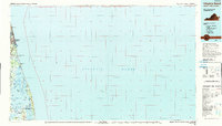 1990 Virginia Beach1990 Print · USGSThe Virginia and North Carolina coastline in the early nineties showcases a landscape of naval installations and protected wildlife corridors. Genealogists and historians can trace the development of Virginia Beach alongside older communities like Dawley Corners and Sigma.
 - 1997 Map of Elizabeth City, 2000 Print
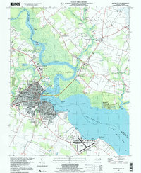 1997 Elizabeth City2000 Print · USGSElizabeth City and its surroundings in the late twentieth century highlight a riverfront community shaped by maritime traffic and aviation. Genealogists and local historians can trace family locations near Sawyers Creek Church, New Oak Grove Cemetery, or the rural crossroads at Hastings Corner.
 - 1997 Map of Lambs Corner, 2000 Print
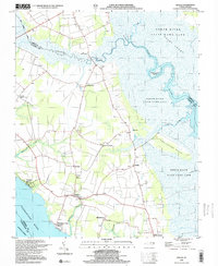
 1997 Lambs Corner2000 Print · USGSCamden and Currituck counties appear at the end of the twentieth century, defined by the massive reach of the Great Dismal Swamp. Genealogists and local historians can trace rural homesteads near Lambs Corner or follow the path of the Guiena Mill Run Canal.
 - 1999 Map of Currituck, 2002 Print
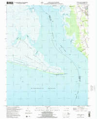
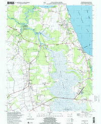 1999 Currituck2002 Print · USGSThe Currituck Sound region at the close of the twentieth century shows a landscape defined by coastal waters and rural crossroads. Genealogists can locate family landmarks like Weeping Mary Ch, Knapp Jr High Sch, and the Knotts Island Ferry.
 - 1999 Map of Point Harbor, 2002 Print
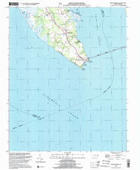 1999 Point Harbor2002 Print · USGSThe Currituck peninsula at the turn of the millennium shows the vital gateway between the northern sounds and the Outer Banks. Researchers can trace local landmarks like Piney Grove Ch and Powells Point or follow the path of the Wright Memorial Bridge.
 - 1999 Map of Camden Point, 2002 Print
 1999 Camden Point2002 Print · USGSThe Currituck and Camden county line meets the Albemarle Sound at the turn of the millennium in this detailed coastal study. Genealogists and historians can locate family burials at several cemeteries and trace the shorelines of Camden Point and Walnut Island.
 - 1999 Map of Barco, 2002 Print
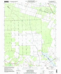
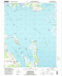 1999 Barco2002 Print · USGSCurrituck Sound and its surrounding marshlands are captured here in the late nineties, documenting a landscape defined by water. Trace the Knotts Island Ferry route, locate the Great Hope Ch in Barco, or explore the narrow lanes of Waterlily.
 - 1999 Map of Shiloh, 2003 Print
 1999 Shiloh2003 Print · USGSCamden County's river-bounded landscape is captured here at the end of the century, showing a region defined by its swamps and coastal reaches. Researchers can locate numerous family cemeteries and early church sites such as New Shiloh Ch and Smiths Corner.
End of results
Showing maps 1-8 of 8
Top cities of Currituck County
Frequently asked questions
- What are the different types of historical maps available for Currituck County?
- What is the oldest map of Currituck County?
- Where can I purchase historical maps of Currituck County for my home or office?
- Where can I download high-res historical maps of Currituck County?
- Are there historical topographic maps available for Currituck County?
- Is there historical aerial imagery available for Currituck County?
- Where are historical maps of Currituck County sourced from?