1940s Maps of Gaston County, North Carolina
Explore 6 historic maps of Gaston County from the 1940s. These maps offer a rare glimpse into what life looked like during the 1940s — showing old roads, neighborhoods, homes, and landmarks that have changed or disappeared over time.
Whether you're researching your family's past, planning a metal detecting trip, or studying how Gaston County's landscape evolved across the 1940s, these high-resolution maps are a powerful tool for exploring the history of this region.
- Focus on a specific era: All maps on this page are from the 1940s, giving you a focused view of this time period.
- See what’s changed: Compare century-old streets, trails, and buildings to today's modern landscape using overlays and satellite layers.
- Research with precision: Use these maps for genealogy, historical research, land use analysis, or educational projects.
- View, download, or print: Maps are fully viewable online in high resolution, and can be downloaded or printed for your own records.
Start exploring Gaston County's history through authentic maps from the 1940s. This is your window into the past.
Gaston County, NC maps
(6)- 1941 Map of Charlotte
 1941 Charlotte1941 Print · USGSMecklenburg and its surrounding counties are captured here at a pivotal moment in the early 1940s. Genealogists and local historians can trace the rail-driven growth of Charlotte or locate smaller rural landmarks like Alexanders Store, Wesley Chapel, and the community at Stallings.
 - 1942 Map of Charlotte
 1942 Charlotte1942 Print · USGSCharlotte and its surrounding Piedmont communities are captured here during the early years of the Second World War. Researchers can trace the rail corridors of the Southern and Seaboard Air Line or locate family-named sites like Alexanders Store, Hoods Cross Road, and Wesley Chapel.2 unique versions available
 - 1947 Map of Clover, 1956 Print
 1947 Clover1956 Print · USGSThe Carolina Piedmont at the dawn of the postwar era shows a landscape of textile mills and rural farmsteads along the rising waters of the Catawba. Local historians can trace the foundations of the region through landmarks like the State Textile Sch, Boogertown, and the Buster Boyd Bridge.2 unique versions available
 - 1948 Map of Paw Creek, 1952 Print
 1948 Paw Creek1952 Print · USGSThe rural outskirts of Charlotte and the Catawba River shoreline are captured here just after the war. Local historians can trace the foundations of communities like Shuffletown and Toddville, or locate landmarks such as Hopewell Ch and the Paw Creek High Sch.
 - 1949 Map of Clover
 1949 Clover1949 Print · USGSThe Carolinas' borderlands come alive in the late 1940s as the textile and rail economy centers around Lake Wylie. Researchers can trace old family roots at China Grove Ch, locate the vanished Shiny Eye Sch, or follow the Southern Ry through Belmont and Clover.
 - 1949 Map of Hicks Crossroads
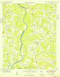 1949 Hicks Crossroads1949 Print · USGSIn the late 1940s, the Catawba River valley still flowed through its original channel, long before the creation of Lake Norman. Local historians can trace the foundations of the Piedmont through rural landmarks like Cowans Ford, Rural Hill Cem, and the cluster of churches at Hicks Crossroads.
End of results
Showing maps 1-6 of 6
Top cities of Gaston County
- Gastonia historical maps
- Mount Holly historical maps
- Belmont historical maps
- Cherryville historical maps
- Bessemer City historical maps
- Dallas historical maps
See more
Frequently asked questions
- What are the different types of historical maps available for Gaston County?
- What is the oldest map of Gaston County?
- Where can I purchase historical maps of Gaston County for my home or office?
- Where can I download high-res historical maps of Gaston County?
- Are there historical topographic maps available for Gaston County?
- Is there historical aerial imagery available for Gaston County?
- Where are historical maps of Gaston County sourced from?