1970s Maps of Sunnyside, North Carolina
Explore 2 historic maps of Sunnyside from the 1970s. These maps offer a rare glimpse into what life looked like during the 1970s — showing old roads, neighborhoods, homes, and landmarks that have changed or disappeared over time.
Whether you're researching your family's past, planning a metal detecting trip, or studying how Sunnyside's landscape evolved across the 1970s, these high-resolution maps are a powerful tool for exploring the history of this region.
- Focus on a specific era: All maps on this page are from the 1970s, giving you a focused view of this time period.
- See what’s changed: Compare century-old streets, trails, and buildings to today's modern landscape using overlays and satellite layers.
- Research with precision: Use these maps for genealogy, historical research, land use analysis, or educational projects.
- View, download, or print: Maps are fully viewable online in high resolution, and can be downloaded or printed for your own records.
Start exploring Sunnyside's history through authentic maps from the 1970s. This is your window into the past.
Sunnyside, NC maps
(2)- 1973 Map of Bessemer City, 1976 Print
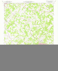 1973 Bessemer City1976 Print · USGSGaston and Cleveland counties come into sharp focus in the early seventies as industrial centers and rural crossroads meet along the rail lines. Genealogists can locate family landmarks like Patterson Grove Ch, while researchers can trace the footprint of local industry at the Mines and Tailings Ponds.
 - 1976 Map of Bessemer City, 1978 Print
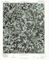 1976 Bessemer City1978 Print · USGSGaston County enters the mid-seventies with a landscape defined by industrial growth and traditional farming. Researchers can trace the literal footprint of the era's textile and mining operations near Bessemer City, Kings Mountain, and Tryon.
End of results
Showing maps 1-2 of 2
Top cities near Sunnyside
- Gastonia historical maps
- Shelby historical maps
- Lincolnton historical maps
- Kings Mountain historical maps
- Cherryville historical maps
- Bessemer City historical maps
See more
Frequently asked questions
- What are the different types of historical maps available for Sunnyside?
- What is the oldest map of Sunnyside?
- Where can I purchase historical maps of Sunnyside for my home or office?
- Where can I download high-res historical maps of Sunnyside?
- Are there historical topographic maps available for Sunnyside?
- Is there historical aerial imagery available for Sunnyside?
- Where are historical maps of Sunnyside sourced from?