1960s Maps of Gates County, North Carolina
Explore 3 historic maps of Gates County from the 1960s. These maps offer a rare glimpse into what life looked like during the 1960s — showing old roads, neighborhoods, homes, and landmarks that have changed or disappeared over time.
Whether you're researching your family's past, planning a metal detecting trip, or studying how Gates County's landscape evolved across the 1960s, these high-resolution maps are a powerful tool for exploring the history of this region.
- Focus on a specific era: All maps on this page are from the 1960s, giving you a focused view of this time period.
- See what’s changed: Compare century-old streets, trails, and buildings to today's modern landscape using overlays and satellite layers.
- Research with precision: Use these maps for genealogy, historical research, land use analysis, or educational projects.
- View, download, or print: Maps are fully viewable online in high resolution, and can be downloaded or printed for your own records.
Start exploring Gates County's history through authentic maps from the 1960s. This is your window into the past.
Gates County, NC maps
(3)- 1967 Map of Whaleyville, 1969 Print
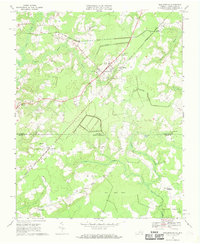 1967 Whaleyville1969 Print · USGSThe Virginia and North Carolina borderlands come into focus in the late sixties, where the railroad meets the great pocosin swamps. Genealogists can trace family roots through Whaleyville and Somerton, or locate rural landmarks like Piney Wood Chapel and Robertson Sch.3 unique versions available
 - 1967 Map of Gates, 1970 Print
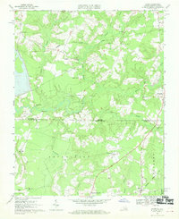 1967 Gates1970 Print · USGSThe Virginia and North Carolina borderlands come into focus during the late sixties, showcasing a landscape of dispersed hamlets and dense cypress swamps. Trace family roots and local history through community landmarks like Pittmantown, Olive Branch Ch, and the rail junction at Gates.2 unique versions available
 - 1967 Map of Riverdale, 1970 Print
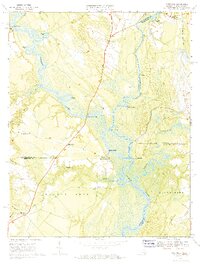 1967 Riverdale1970 Print · USGSThe convergence of the Blackwater and Nottoway Rivers at the Virginia-North Carolina border defines this late-1960s landscape. Researchers can trace the legacy of river commerce and local genealogy through numerous sites like Cobbs Wharf, Riddicksville, and Diamond Grove Ch.3 unique versions available
End of results
Showing maps 1-3 of 3
Top cities of Gates County
Frequently asked questions
- What are the different types of historical maps available for Gates County?
- What is the oldest map of Gates County?
- Where can I purchase historical maps of Gates County for my home or office?
- Where can I download high-res historical maps of Gates County?
- Are there historical topographic maps available for Gates County?
- Is there historical aerial imagery available for Gates County?
- Where are historical maps of Gates County sourced from?