1960s Maps of Graham County, North Carolina
Explore 8 historic maps of Graham County from the 1960s. These maps offer a rare glimpse into what life looked like during the 1960s — showing old roads, neighborhoods, homes, and landmarks that have changed or disappeared over time.
Whether you're researching your family's past, planning a metal detecting trip, or studying how Graham County's landscape evolved across the 1960s, these high-resolution maps are a powerful tool for exploring the history of this region.
- Focus on a specific era: All maps on this page are from the 1960s, giving you a focused view of this time period.
- See what’s changed: Compare century-old streets, trails, and buildings to today's modern landscape using overlays and satellite layers.
- Research with precision: Use these maps for genealogy, historical research, land use analysis, or educational projects.
- View, download, or print: Maps are fully viewable online in high resolution, and can be downloaded or printed for your own records.
Start exploring Graham County's history through authentic maps from the 1960s. This is your window into the past.
Graham County, NC maps
(8)- 1960 Map of Knoxville
 1960 Knoxville1960 Print · USGSThe Southern Appalachians come alive in the 1950s, showing the intersection of new national park tourism and deep-rooted mountain industry. Trace old rail lines like the Clinchfield RR and find high-altitude landmarks from Mt Le Conte to the Cherokee Indian Reservation.2 unique versions available
 - 1960 Map of Chattanooga
 1960 Chattanooga1960 Print · USGSSoutheast Tennessee and the southern Appalachians are shown here at the height of the river-management era. You can trace the valley rail lines and locate Lookout Mountain and the expansive waters of Chickamauga Reservoir.
 - 1961 Map of Noland Creek, 1964 Print
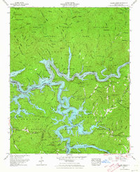 1961 Noland Creek1964 Print · USGSThe North Carolina Smokies are shown here in the early sixties as the massive reservoirs of the TVA reshaped the mountain valleys. Genealogists and hikers can trace remote burial sites like Panther Creek Cem and shoreline landmarks including Sawyer Dock.5 unique versions available
 - 1961 Map of Fontana Dam, 1964 Print
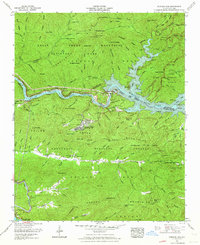 1961 Fontana Dam1964 Print · USGSIn the early sixties, the rugged border of the Great Smokies and Nantahala National Forest shows a landscape shaped by water and timber. Genealogists can locate family burial sites at Proctor Field Gap Cem and Fontana Cem or trace the early Appalachian Trail.4 unique versions available
 - 1961 Map of Tuskeegee, 1964 Print
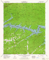 1961 Tuskeegee1964 Print · USGSThe wilderness of western North Carolina is documented here in the early sixties as the sprawling waters of Fontana Lake divide the high Smokies from the Nantahala. Genealogists can trace family roots through numerous remote burial sites like Gunter Cem and Mitchell Cem or locate the riverside settlement at Proctor.4 unique versions available
 - 1961 Map of Wesser, 1965 Print
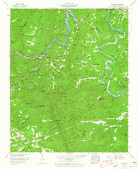 1961 Wesser1965 Print · USGSThe North Carolina mountains come alive in the early sixties as the Southern railroad winds through the dramatic Nantahala Gorge. Genealogists and local historians can trace family-named sites like Almond, Needmore, and the Maple Springs Cem.4 unique versions available
 - 1964 Map of Chattanooga
 1964 Chattanooga1964 Print · USGSSoutheast Tennessee and the western Carolinas appear in the mid-sixties as a powerhouse of river-driven industry and mountain wilderness. Genealogists and historians can trace rail-town lineages along the Southern Ry or locate family landmarks near Watts Bar Lake and Tellico Plains.
 - 1964 Map of Knoxville
 1964 Knoxville1964 Print · USGSThe Southern Appalachians and Great Smokies are captured here during the mid-sixties, showing the rugged borderlands of Tennessee and North Carolina. Researchers can trace historic mountain routes like U S 441, the expanse of Pisgah National Forest, and the growing footprints of Asheville and Knoxville.
End of results
Showing maps 1-8 of 8
Top cities of Graham County
Frequently asked questions
- What are the different types of historical maps available for Graham County?
- What is the oldest map of Graham County?
- Where can I purchase historical maps of Graham County for my home or office?
- Where can I download high-res historical maps of Graham County?
- Are there historical topographic maps available for Graham County?
- Is there historical aerial imagery available for Graham County?
- Where are historical maps of Graham County sourced from?