Old Maps of Graham County, North Carolina for Hiking & Exploration
Hike through history with 140 historic maps of Graham County. Explore old trails, ghost towns, and forgotten backroads — perfect for outdoor adventurers and local explorers.
- Rediscover forgotten places: Map out old mining camps, roads, and footpaths that no longer exist on modern maps.
- Layer with modern tools: Combine with LiDAR or satellite views to plan hikes through historical terrain.
- Made for exploration: Popular among hikers, overlanders, and local history lovers.
Use these maps to find adventure and explore the hidden past of Graham County.
Graham County, NC maps
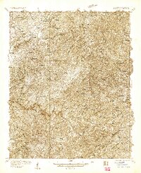
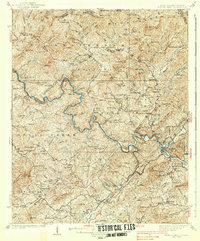
(140)- 1893 Map of Murphy
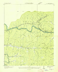
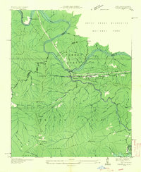
 1893 Murphy1893 Print · USGSThe Unaka Mountains and Hiwassee River valley are captured here in the late 19th century, showing a landscape of remote mountain gaps and early industry. Researchers can find old mining sites like Isabella Mine, river crossings such as Prince Fy., and rail stops at Hiwassee Sta..5 unique versions available
 - 1914 Map of Murphy
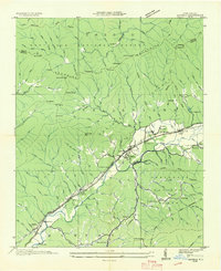
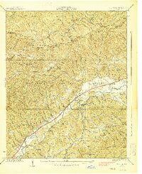
 1914 Murphy1914 Print · USGSThe Tennessee-North Carolina borderlands come to life in this early twentieth-century survey, showcasing a landscape of mountain ridges and river-driven commerce. Researchers can trace the Louisville and Nashville Railroad to old stops like Apalachia Sta or locate the historic Prince Ferry and White Cliff Springs.3 unique versions available
 - 1927 Map of Big Junction
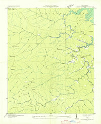
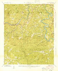
 1927 Big Junction1927 Print · USGSThe Tennessee-North Carolina high country comes alive in this late 1920s survey of the Unicoi Mountains. Trace old mountain routes and clearings like Whigg Cabin, Stratton Meadow, and the headwaters of the Tellico River.2 unique versions available
 - 1933 Map of Haw Knob
 1933 Haw Knob1933 Print · USGSThe Tennessee-North Carolina borderlands come alive in this early 1930s survey, showing the deep creek valleys and high peaks of the southern mountains. Researchers can find old community hubs like Tallassee Sch, Ballplay Ch, and the remote Hemlock Lookout.2 unique versions available
 - 1933 Map of Whiteoak Flats
 1933 Whiteoak Flats1933 Print · USGSThe Tennessee and North Carolina borderlands come into focus in the early 1930s, showing the high ridges and creek valleys before modern development. Genealogists and hikers can trace old routes near Pleasant Grove Church, Jeffrey, and the summits of the Unicoi Mountains.
 - 1933 Map of Bushnell
 1933 Bushnell1933 Print · USGSSwain County high country in the late 1920s is defined by a remote landscape of steep ridges and small mountain schools. Researchers can trace the locations of Mill Creek Sch and School No 2 or identify family landmarks like Loudermilk Ridge and Welch Bald.
 - 1934 Map of McDaniel Bald
 1934 McDaniel Bald1934 Print · USGSThe North Carolina and Tennessee borderlands appear here in the mid-1930s, showing a network of high-elevation gaps and remote mountain schools. Genealogists can locate family landmarks like Bryson Cem, Ebenezer, and schools including Owl Creek Sch and Davis Creek Sch.
 - 1934 Map of Murphy
 1934 Murphy1934 Print · USGSWestern North Carolina during the mid-thirties reveals a mountain landscape transitioning from resource extraction to managed forest. Researchers can trace family roots at Old Friendship Cem or locate industrial sites like Culberson Mine and Regal Sta.
 - 1935 Map of Robbinsville
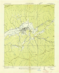
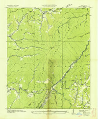
 1935 Robbinsville1935 Print · USGSRobbinsville and the surrounding Blue Ridge high country are documented here in the mid-thirties, showing the early footprint of the lake and national forest. Genealogists can trace family landmarks like the Snowbird Cherokee Indian Sch, West Buffalo Cem, and the Graham County R R.
 - 1935 Map of Fontana
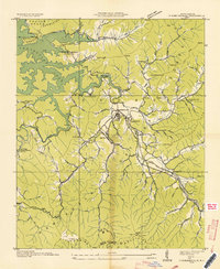
 1935 Fontana1935 Print · USGSGraham County and the Little Tennessee River valley are shown here just prior to the massive Tennessee Valley Authority dam projects of the late 1930s. Researchers can trace the original river course and rail lines, locating the Fontana Copper Mine, Rymers Ferry, and the Yellow Creek Cem.
 - 1935 Map of Topton
 1935 Topton1935 Print · USGSWestern North Carolina’s mountain timber and rail landscape is captured here in the mid-thirties as federal relief work takes root. Trace the winding Ritter Lumber RR alongside CCC Camp No F 13 and the remote settlement of Aquone.
 - 1935 Map of Marble
 1935 Marble1935 Print · USGSCherokee County enters a period of industrial growth in the mid-1930s as the Valley River becomes a corridor for rail and mining. Researchers can trace the heritage of Marble, locate the Talc Mine, and find family sites like Moss Cem or Oak Grove Sch.
 - 1935 Map of Wayah Bald
 1935 Wayah Bald1935 Print · USGSHigh in the Blue Ridge Mountains during the mid-1930s, this survey reveals the isolated homesteads and forest tracts of Macon County. Genealogists can locate family landmarks like Marshall Chapel, Oakdale Sch, and the remote Kyle PO or Flats PO.
 - 1935 Map of Santeetlah Creek
 1935 Santeetlah Creek1935 Print · USGSGraham County's mountain landscape is captured here in the mid-1930s, showing a world of remote ridges and creeks within the Nantahala National Forest. Genealogists can locate community cornerstones like Cedar Cliff Ch, Snowbird Sch, and the Cherokee Lodge (Abandoned).
 - 1935 Map of Andrews
 1935 Andrews1935 Print · USGSMid-1930s Cherokee County centers on the rail-driven town of Andrews as it sits between the Snowbird Mountains and Tusquitee Mountains. Genealogists and historians can trace local landmarks like Valleytown Cem, the Junaluska Sch, and the unique Valley River Tunnel.
 - 1935 Map of Tapoco
 1935 Tapoco1935 Print · USGSThe border of North Carolina and Tennessee comes alive in the 1930s as massive hydroelectric projects reshape the high country. Trace the early Appalachian Trail through Deals Gap alongside industrial landmarks like Cheoah Dam and Tapoco.
 - 1936 Map of Proctor
 1936 Proctor1936 Print · USGSThe Little Tennessee River valley is captured here in the mid-1930s just as the Tennessee Valley Authority began its regional transformations. Genealogists can trace family names at Proctor Cem and Sawyer Creek Cem, or locate schools like Calhoun Coburn Sch.
 - 1936 Map of Wesser
 1936 Wesser1936 Print · USGSThe Southern Appalachian highlands are captured here in the mid-1930s, showing a landscape defined by timber flumes and the Southern Railway. Genealogists can locate family landmarks like Wright Place, early schools such as Silvermine Sch, and numerous mountain burials including Euchulla Cem.
 - 1936 Map of Hewitt
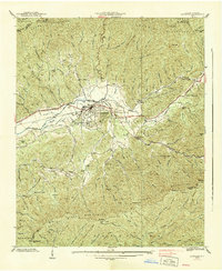
 1936 Hewitt1936 Print · USGSGraham County's high ridges and river gorges are captured here in the mid-1930s, just as the regional infrastructure was being formalized by the Tennessee Valley Authority. Researchers can trace the early Appalachian Trail or locate family sites like Jenkins Cem, Rowlin Sch, and the Cheoah Mill.
 - 1936 Map of Judson
 1936 Judson1936 Print · USGSThe confluence of the Little Tennessee and Tuckasegee rivers is captured here in the mid-1930s, just before the landscape was transformed by reservoir projects. Researchers can trace the original rail stops and riverside communities of Bushnell, Judson, and Almond, along with rural landmarks like Mt Zion Ch and Noland Creek Sch.
 - 1937 Map of Haw Knob
 1937 Haw Knob1937 Print · USGSMonroe County and the borderlands of the Smokies are captured in the mid-1930s as the national forest system expanded across these high ridges. Genealogists and local historians can locate early landmarks like Whigg Cabin, Ballplay Church, and the isolated Waucheesi School.
 - 1938 Map of Andrews
 1938 Andrews1938 Print · USGSWestern North Carolina mountain life is centered on the Andrews valley in the late thirties as the Southern railroad connects these high peaks. Genealogists and hikers can trace old routes through Granny Squirrel Gap, locate the Valleytown Cem, or find the State Prison Camp.7 unique versions available
 - 1938 Map of Fowler Bend
 1938 Fowler Bend1938 Print · USGSThe mountain landscape of Cherokee County is captured in the mid-1930s, just as the Nottely Dam began reshaping the river valleys. Local historians can trace early community hubs like Dockery Store, the L & N RR, and the Henson Donation Indian Reservation.2 unique versions available
 - 1938 Map of Marble
 1938 Marble1938 Print · USGSWestern North Carolina’s mountain valleys are captured here in the late 1930s as the rail-and-river economy centered on Marble thrived. Researchers can locate early schools and churches like Slow Creek Sch and Fairview Ch, alongside industrial markers like Terrazzo Switch.6 unique versions available
 - 1940 Map of Wesser
 1940 Wesser1940 Print · USGSThe Nantahala Gorge and the winding Little Tennessee River define this high-country landscape as it appeared in the early 1940s. Genealogists can trace family footprints at Watia Ch, Tabor Cem, and mountain schools like Hightower Sch.2 unique versions available
Showing maps 1-25 of 140
Top cities of Graham County
Frequently asked questions
- What are the different types of historical maps available for Graham County?
- What is the oldest map of Graham County?
- Where can I purchase historical maps of Graham County for my home or office?
- Where can I download high-res historical maps of Graham County?
- Are there historical topographic maps available for Graham County?
- Is there historical aerial imagery available for Graham County?
- Where are historical maps of Graham County sourced from?