1950s Maps of Granville County, North Carolina
Explore 8 historic maps of Granville County from the 1950s. These maps offer a rare glimpse into what life looked like during the 1950s — showing old roads, neighborhoods, homes, and landmarks that have changed or disappeared over time.
Whether you're researching your family's past, planning a metal detecting trip, or studying how Granville County's landscape evolved across the 1950s, these high-resolution maps are a powerful tool for exploring the history of this region.
- Focus on a specific era: All maps on this page are from the 1950s, giving you a focused view of this time period.
- See what’s changed: Compare century-old streets, trails, and buildings to today's modern landscape using overlays and satellite layers.
- Research with precision: Use these maps for genealogy, historical research, land use analysis, or educational projects.
- View, download, or print: Maps are fully viewable online in high resolution, and can be downloaded or printed for your own records.
Start exploring Granville County's history through authentic maps from the 1950s. This is your window into the past.
Granville County, NC maps
(8)- 1951 Map of Durham North, 1953 Print
 1951 Durham North1953 Print · USGSThe northern reaches of Durham and Orange Counties are captured here in the early fifties, just as post-war development began to meet the region's agricultural roots. Genealogists can trace family landmarks like the Duke Homestead and rural hubs such as Bahama, Rougemont, and the Orange Factory.3 unique versions available
 - 1953 Map of Oxford
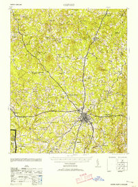 1953 Oxford1953 Print · USGSGranville County during the mid-century shows a landscape of busy rail junctions and rural tobacco-country crossroads. Genealogists can trace family landmarks like John Penns Grave, Wilbourns Store, and the scattered schoolhouses of Huntsboro and Stovall.2 unique versions available
 - 1953 Map of South Boston, 1955 Print
 1953 South Boston1955 Print · USGSThe Virginia Southside in the early fifties shows a bustling rail-and-river economy centered on the tobacco and textile hub of South Boston. Genealogists and historians can trace family locations through numerous rural landmarks like Berry Hill, the Wall Mine, and Orange Grove Sch.2 unique versions available
 - 1953 Map of Greensboro, 1981 Print
 1953 Greensboro1981 Print · USGSThe Piedmont borderlands of North Carolina and Virginia show a landscape defined by new reservoirs and old rail lines. Trace family roots and the changing river geography through Elon College, the John H Kerr Reservoir, and South Boston.
 - 1954 Map of Greensboro
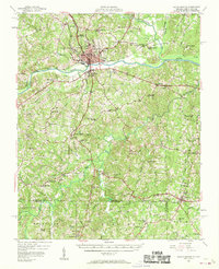
 1954 Greensboro1954 Print · USGSThe Piedmont borderlands of North Carolina and Virginia come alive in this mid-fifties study of a region defined by its rivers and rails. Researchers can trace the growing Buggs Island Lake or follow the paths of the Southern Ry and Seaboard Air Line RR through towns like Oxford and Reidsville.
 - 1955 Map of Boydton, 1957 Print
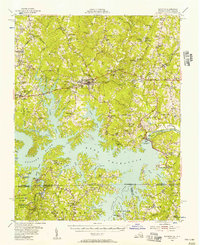 1955 Boydton1957 Print · USGSMecklenburg County and the Virginia-North Carolina border are shown here during the mid-fifties, just as the newly formed Kerr Reservoir reshaped the Roanoke River valley. Genealogists and local historians can trace family-named sites like Dodson Corner and Rogers Corner or locate vanished landmarks like Island Hill Sch.2 unique versions available
 - 1957 Map of South Boston, 1958 Print
 1957 South Boston1958 Print · USGSSouth Boston and the surrounding borderlands of Virginia and North Carolina are captured here in the mid-fifties, centered on the confluence of the Banister and Dan Rivers. Genealogists and historians can trace numerous rural landmarks, including the Wolf Mine Sch, Five Forks Cem, and the settlement of Virgilina.3 unique versions available
 - 1957 Map of Clarksville, 1959 Print
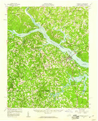 1957 Clarksville1959 Print · USGSSouthern Mecklenburg County and the North Carolina borderlands are captured here in the late fifties, just as Kerr Reservoir reshaped the local geography. Family historians can trace ancestral sites like Siddon Hebron Ch, Wharton Memorial, and the West End High Sch.2 unique versions available
End of results
Showing maps 1-8 of 8
Top cities of Granville County
- Oxford historical maps
- Butner historical maps
- Creedmoor historical maps
- Stovall historical maps
- Stem historical maps
Frequently asked questions
- What are the different types of historical maps available for Granville County?
- What is the oldest map of Granville County?
- Where can I purchase historical maps of Granville County for my home or office?
- Where can I download high-res historical maps of Granville County?
- Are there historical topographic maps available for Granville County?
- Is there historical aerial imagery available for Granville County?
- Where are historical maps of Granville County sourced from?