1990s Maps of Henderson County, North Carolina
Explore 10 historic maps of Henderson County from the 1990s. These maps offer a rare glimpse into what life looked like during the 1990s — showing old roads, neighborhoods, homes, and landmarks that have changed or disappeared over time.
Whether you're researching your family's past, planning a metal detecting trip, or studying how Henderson County's landscape evolved across the 1990s, these high-resolution maps are a powerful tool for exploring the history of this region.
- Focus on a specific era: All maps on this page are from the 1990s, giving you a focused view of this time period.
- See what’s changed: Compare century-old streets, trails, and buildings to today's modern landscape using overlays and satellite layers.
- Research with precision: Use these maps for genealogy, historical research, land use analysis, or educational projects.
- View, download, or print: Maps are fully viewable online in high resolution, and can be downloaded or printed for your own records.
Start exploring Henderson County's history through authentic maps from the 1990s. This is your window into the past.
Henderson County, NC maps
(10)- 1994 Map of Black Mountain, 1998 Print
 1994 Black Mountain1998 Print · USGSBuncombe and McDowell counties appear in the mid-1990s as a high-altitude crossroads for the railway and Interstate 40. Researchers can trace the legacy of local institutions like the Mountain Orphanage and find family landmarks such as Wilkes Church or the Swannanoa Tunnel.
 - 1997 Map of Bat Cave, 2001 Print
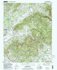
 1997 Bat Cave2001 Print · USGSHenderson County's mountain passes and river gaps are captured here in the late twentieth century, showing the enduring rural layout of the Blue Ridge. Genealogists and hikers can trace family sites like Edneyville Cem or locate historical landmarks including Maxwell Mill and the Bat Caves.
 - 1997 Map of Horse Shoe, 2001 Print
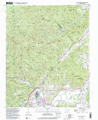
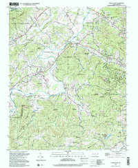 1997 Horse Shoe2001 Print · USGSHenderson County's river-bottom lands and mountain ridges are shown here in the late nineties, centered on the French Broad River. Genealogists can trace family sites like Fletcher Cem and Oak Forest Cem or visit Etowah and Horse Shoe.
 - 1997 Map of Cliffield Mtn., 2001 Print
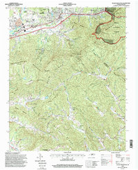
 1997 Cliffield Mtn.2001 Print · USGSThe Henderson and Polk County line comes alive in the 1990s, capturing the steep transition from the Blue Ridge heights to the Green River gorge. Genealogists and hikers can trace old family sites like Stepp Cem and Bradley Cem or locate Bradley Falls near The Narrows.
 - 1997 Map of Hendersonville, 2001 Print
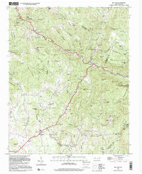
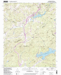
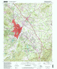 1997 Hendersonville2001 Print · USGSHendersonville and its surrounding ridges are captured in the late nineties, showcasing the growth of this mountain community along the Southern Railway. Researchers can trace local lineages through sites like Oakdale Cem, Jones Cem, and schools such as East Henderson High School.
 - 1997 Map of Standingstone Mtn, 2001 Print
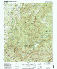
 1997 Standingstone Mtn2001 Print · USGSThe Carolina borderlands are defined by water and woods in the late nineties, where the Blue Ridge begins its steep descent. Trace the path of the Little Little River through landmarks like Bridal Veil Falls and Wabak Camp.
 - 1997 Map of Dunsmore Mountain, 2001 Print
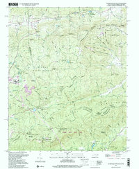
 1997 Dunsmore Mountain2001 Print · USGSThe high ridges and deep gaps of the Blue Ridge south of Asheville are shown here in the late twentieth century. Genealogists and hikers can trace old mountain congregations at Mt Pisgah Church or find historic burial sites like Stony Fork Cem and Stuart Cem.
 - 1997 Map of Pisgah Forest, 2001 Print
 1997 Pisgah Forest2001 Print · USGSThe Brevard area and the headwaters of the French Broad River are captured here in the late twentieth century. Genealogists can trace family names at the McCall Cem and Davidson River Cem or locate centers like Cherry Village and the Penrose Sch.
 - 1997 Map of Fruitland, 2001 Print
 1997 Fruitland2001 Print · USGSThe mountain valleys of Henderson and Buncombe counties come into focus in this late-twentieth-century survey. Genealogists and local historians can trace family landmarks like Pittillo-Lanning Cem and the Fruitland Bible Institute.
 - 1997 Map of Zirconia, 2001 Print
 1997 Zirconia2001 Print · USGSHenderson County, North Carolina, and Greenville County, South Carolina, meet here in the late nineties among the high ridges of the Blue Ridge. Trace local family history and mountain life through Pace Cem, Mountain Valley Sch, and the rail stops at Zirconia.
End of results
Showing maps 1-10 of 10
Top cities of Henderson County
- Hendersonville historical maps
- Fletcher historical maps
- Mills River historical maps
- Flat Rock historical maps
- Laurel Park historical maps
- Balfour historical maps
Frequently asked questions
- What are the different types of historical maps available for Henderson County?
- What is the oldest map of Henderson County?
- Where can I purchase historical maps of Henderson County for my home or office?
- Where can I download high-res historical maps of Henderson County?
- Are there historical topographic maps available for Henderson County?
- Is there historical aerial imagery available for Henderson County?
- Where are historical maps of Henderson County sourced from?