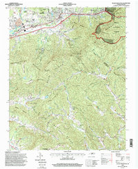
1994 Map of Black Mountain
USGS Topo · Published 1998About this map
Black Mountain and Ridgecrest serve as the primary gateways to this mountainous region of Buncombe and McDowell counties in the mid-1990s. The landscape is defined by the high elevations of the Blue Ridge Mountains and the Swannanoa Mountains, where the Southern Railway traverses the famous Swannanoa Tunnel at the gap. The presence of the Mountain Orphanage, State Hospital, and Fellowship Sanatorium indicates the area's long-standing role in healthcare and social services. Religious and community life is anchored by numerous small houses of worship, such as Curleys Chapel and Elizabeth Chapel, while the Strip Mine near Grovestone points to the local industrial activity. Much of the eastern and southern terrain is protected within the Pisgah National Forest, maintaining the wilderness character of the Broad River headwaters and peaks like High Windy.
Find a feature on this map
86 named features on this map. Tap any name to fly to it.
Don’t see what you’re looking for? This feature index may not catch every label — zoom into the map to look around manually.
Map Details
Editions of this 1994 Black Mountain Map
This is the sole edition of this map. No revisions or reprints were ever made.
Other maps of this area

1900 · Mount Mitchell
USGS Topo · 1:125,000

1902 · Mount Mitchell
USGS Topo · 1:125,000

1907 · Saluda
USGS Topo · 1:125,000

1934 · Parts Of Old Fort and Montreat
USGS Topo · 1:24,000

1935 · Montreat
USGS Topo · 1:24,000

1935 · Batcave
USGS Topo · 1:24,000

1935 · Black Mountain
USGS Topo · 1:24,000

1935 · Craggy Pinnacle
USGS Topo · 1:24,000

1936 · Fruitland
USGS Topo · 1:24,000

1941 · Black Mountain
USGS Topo · 1:24,000