
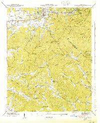
1935 Map of Batcave
USGS Topo · Published 1935About this map
Edneyville serves as the primary hub of this 1935 landscape, where the Blue Ridge mountains define the settlement patterns of Henderson and Buncombe counties. This advance sheet, compiled from aerial photography by the Tennessee Valley Authority, reveals a high-altitude agricultural and forest community organized around numerous country churches and schools. A network of rural structures including Barnwell Ch, Liberty Ch, and Mt Moriah Ch suggests a deeply rooted social fabric in the mountain hollows. The terrain is marked by significant peaks such as Bearwallow Mtn, which features a prominent Fire Tower, and Whiteside Mtn. Waterways like Clear Creek and Cane Creek wind through the valleys, providing the natural corridors for early state routes including State No 20 and State No 28 as they navigate the steep gaps and ridges of the southern Appalachians.
Find a feature on this map
47 named features on this map. Tap any name to fly to it.
Don’t see what you’re looking for? This feature index may not catch every label — zoom into the map to look around manually.
Map Details
Editions of this 1935 Batcave Map
This is the sole edition of this map. No revisions or reprints were ever made.
Other maps of this area

1900 · Mount Mitchell
USGS Topo · 1:125,000

1902 · Mount Mitchell
USGS Topo · 1:125,000

1907 · Saluda
USGS Topo · 1:125,000

1935 · Hendersonville
USGS Topo · 1:24,000

1935 · Black Mountain
USGS Topo · 1:24,000

1935 · Fishtop
USGS Topo · 1:24,000

1936 · Fruitland
USGS Topo · 1:24,000

1941 · Black Mountain
USGS Topo · 1:24,000

1942 · Fruitland
USGS Topo · 1:24,000
1943 · Black Mountain
USGS Topo · 1:24,000