1970s Maps of Flat Rock, North Carolina
Explore 2 historic maps of Flat Rock from the 1970s. These maps offer a rare glimpse into what life looked like during the 1970s — showing old roads, neighborhoods, homes, and landmarks that have changed or disappeared over time.
Whether you're researching your family's past, planning a metal detecting trip, or studying how Flat Rock's landscape evolved across the 1970s, these high-resolution maps are a powerful tool for exploring the history of this region.
- Focus on a specific era: All maps on this page are from the 1970s, giving you a focused view of this time period.
- See what’s changed: Compare century-old streets, trails, and buildings to today's modern landscape using overlays and satellite layers.
- Research with precision: Use these maps for genealogy, historical research, land use analysis, or educational projects.
- View, download, or print: Maps are fully viewable online in high resolution, and can be downloaded or printed for your own records.
Start exploring Flat Rock's history through authentic maps from the 1970s. This is your window into the past.
Flat Rock, NC maps
(2)- 1977 Map of Hendersonville, 1979 Print
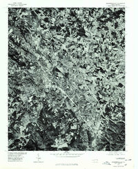 1977 Hendersonville1979 Print · USGSHendersonville and the surrounding Blue Ridge plateau are captured in detail during the late seventies using high-resolution aerial imagery. Trace the urban expansion of Hendersonville and the industrial footprint of East Flat Rock as they appeared decades ago.
 - 1977 Map of Zirconia, 1979 Print
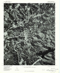 1977 Zirconia1979 Print · USGSThe mountain borderlands of Henderson County appear in sharp relief during the late seventies. Researchers can trace the sprawling shorelines of Lake Summit and the Poinsett Reservoir to study regional water history and land use.
End of results
Showing maps 1-2 of 2
Top cities near Flat Rock
- Asheville historical maps
- Greer historical maps
- Hendersonville historical maps
- Fletcher historical maps
- Brevard historical maps
- Mills River historical maps
See more
Top neighborhoods of Flat Rock
- Beaumont historical maps
- Claremont historical maps
- Ravenwood historical maps
- Woodhaven historical maps
- Kingswood historical maps
- Tranquility historical maps
See more
Frequently asked questions
- What are the different types of historical maps available for Flat Rock?
- What is the oldest map of Flat Rock?
- Where can I purchase historical maps of Flat Rock for my home or office?
- Where can I download high-res historical maps of Flat Rock?
- Are there historical topographic maps available for Flat Rock?
- Is there historical aerial imagery available for Flat Rock?
- Where are historical maps of Flat Rock sourced from?