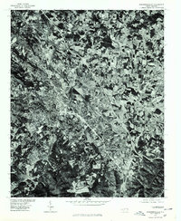
1977 Map of Hendersonville
USGS Topo · Published 1979About this map
Hendersonville is the focal point of this 1977 orthophotoquad, which replaces the traditional topographic line drawing with rectified aerial imagery. Produced in cooperation with the Soil Conservation Service, the map provides a high-contrast overhead view of the land use patterns during the late 1970s. The dense urban grid of the city transitions into the neighboring community of East Flat Rock, revealing the extensive industrial and residential expansion following the path of the regional transportation corridors. This specific format offers researchers a precise visual record of field boundaries, forest cover, and suburban development that traditional contour maps often generalize, making it an essential resource for understanding the physical growth of these Blue Ridge plateau settlements.
Find a feature on this map
2 named features on this map. Tap any name to fly to it.
Don’t see what you’re looking for? This feature index may not catch every label — zoom into the map to look around manually.
Map Details
Editions of this 1977 Hendersonville Map
This is the sole edition of this map. No revisions or reprints were ever made.
Other maps of this area

1905 · Pisgah
USGS Topo · 1:125,000

1906 · Pisgah
USGS Topo · 1:125,000

1907 · Saluda
USGS Topo · 1:125,000

1935 · Standingstone Mtn.
USGS Topo · 1:24,000

1935 · Horse Shoe
USGS Topo · 1:24,000

1935 · Batcave
USGS Topo · 1:24,000

1935 · Hendersonville
USGS Topo · 1:24,000

1935 · Fishtop
USGS Topo · 1:24,000

1935 · Zirconia
USGS Topo · 1:24,000

1936 · Skyland
USGS Topo · 1:24,000