Old Maps of Flat Rock, North Carolina for Genealogy
Trace your family roots with 41 historic maps of Flat Rock. These high-res maps reveal old neighborhoods, homesites, landmarks, and streets — helping you uncover where your ancestors lived and how the area evolved over time.
- Explore historic neighborhoods: Identify where your relatives may have lived in the 1800s or 1900s.
- Compare maps over time: Trace the changes in streets, buildings, and landmarks for multi-generational research.
- Perfect for genealogy & ancestry research: Used by family historians and researchers to map out lineage and migration.
These maps are an incredible resource for exploring your personal connection to Flat Rock's past.
Flat Rock, NC maps
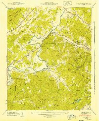
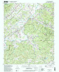
(41)- 1905 Map of Pisgah, 1956 Print
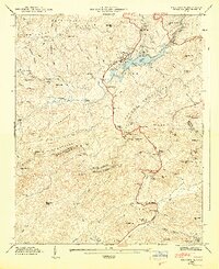
 1905 Pisgah1956 Print · USGSThe North Carolina high country around the turn of the century reveals a land of timber tracts and emerging mountain retreats. Genealogists and hikers can trace early routes to Buck Spring Lodge, follow the Southern RR tracks, and locate vanished settlements like Angeline and Calhoun.
 - 1906 Map of Pisgah, 1934 Print
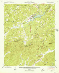
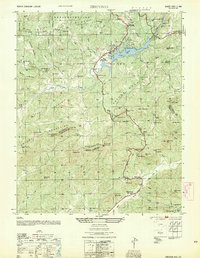
 1906 Pisgah1934 Print · USGSThe Blue Ridge highlands at the turn of the century reveal a landscape of mountain river valleys and early timber frontiers. Genealogists and historians can trace family-named bridges and crossings like Graham Bridge or locate vanished settlements such as Grange and Retreat.2 unique versions available
 - 1907 Map of Saluda
 1907 Saluda1907 Print · USGSNorth Carolina's mountain frontier meets the South Carolina foothills in this 1900s survey of the Blue Ridge. Genealogists and researchers can trace the early rail network through Saluda and locate old landmarks like Rockcliff PO and Pleasant Grove Church.3 unique versions available
 - 1935 Map of Horse Shoe
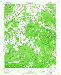
 1935 Horse Shoe1935 Print · USGSWestern North Carolina's river valleys and mountain ridges are documented here in the mid-1930s as the Southern Railroad winds along the French Broad River. Researchers can trace old family sites and rural infrastructure including Prison Camp No 511, Oakdale Cem, and the historic Sewell House.
 - 1935 Map of Hendersonville
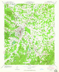
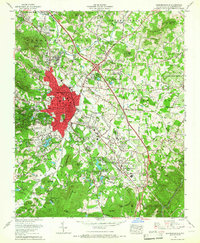
 1935 Hendersonville1935 Print · USGSHenderson County is captured in the mid-1930s as a bustling crossroads of rail transit and mountain agriculture. Genealogists and historians can trace the foundations of Hendersonville along the Southern Railway, locating the Military Academy, the Orphanage, and old family burial sites like Jones Cem.
 - 1935 Map of Zirconia
 1935 Zirconia1935 Print · USGSHenderson County in the mid-1930s is shown here in an early aerial-photograph survey of the high ridge lines. Genealogists and hikers can trace old mountain trails near Mt Olivet Ch, the peaks of McAlpine Mtn, and the community at Gem.
 - 1942 Map of Horse Shoe
 1942 Horse Shoe1942 Print · USGSThe French Broad River valley is captured here in the early 1940s as a thriving network of rail-side settlements and mountain gaps. Genealogists and historians can trace family landmarks like Mc Carson Cem, Oak Forest Ch, and the old Southern Railway line.2 unique versions available
 - 1946 Map of Zirconia, 1957 Print
 1946 Zirconia1957 Print · USGSThe Blue Ridge and Saluda Mountains come together at the Carolina state line during the mid-1940s. Local researchers can trace family landmarks like Pace Cem, the Fall Creek Sch, and the numerous recreational sites surrounding Lake Summit.4 unique versions available
 - 1946 Map of Hendersonville, 1957 Print
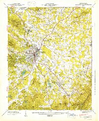
 1946 Hendersonville1957 Print · USGSHenderson County in the mid-1940s is captured here at a peak of rail and resort development. Researchers can locate family names at Stanford Chapel, trace the Southern railroad through Balfour, or find old crossings like Buckeye Ford.2 unique versions available
 - 1947 Map of Hendersonville
 1947 Hendersonville1947 Print · USGSHendersonville and its surrounding apple country are captured in the late 1940s just as post-war growth began to shape the plateau. Genealogists and historians can trace family locations near Balfour, Highland Lake, and several rural landmarks like Draffin Hall Ch.2 unique versions available
 - 1947 Map of Zirconia
 1947 Zirconia1947 Print · USGSCrossing the state line between Henderson and Greenville counties in the late 1940s, this area showcases a landscape of high peaks and hydroelectric development. Researchers can locate family landmarks such as Page Cem, Fall Creek Sch, and the old station at Zirconia.2 unique versions available
 - 1954 Map of Zirconia
 1954 Zirconia1954 Print · USGSThe Carolina borderlands come alive in the mid-fifties, showing the intersection of the Saluda Mountains and the Green River. Researchers can trace old family burial grounds like Page Cem, visit the settlement at Tuxedo, or locate historic landmarks like the Corbin Mtn Lookout Tower.
 - 1955 Map of Knoxville
 1955 Knoxville1955 Print · USGSThe Southern Appalachians and the Smoky Mountains are shown here at a peak of mid-century development and conservation. Genealogists and historians can trace the early road networks connecting Gatlinburg, Waynesville, and the Cherokee Indian Reservation across the high ridges.
 - 1957 Map of Knoxville, 1966 Print
 1957 Knoxville1966 Print · USGSThe Southern Appalachians of Tennessee and North Carolina are mapped here during the mid-twentieth century as new highways reached the high country. Genealogists and historians can trace the topography between Knoxville and Asheville, locating family landmarks near Fontana Lake or along the Blue Ridge Parkway.4 unique versions available
 - 1959 Map of Zirconia, 1962 Print
 1959 Zirconia1962 Print · USGSThe Blue Ridge and Saluda Mountains meet during the late fifties, showcasing a landscape of high peaks and managed reservoirs. Trace family roots and mountain settlements through Mount Olive Ch, Andrews Cem, and the rail stop at Tuxedo Station.3 unique versions available
 - 1959 Map of Tigerville, 1963 Print
 1959 Tigerville1963 Print · USGSThe Carolina borderlands come into focus in the late fifties as the Blue Ridge foothills balance mountain industry and rural education. Researchers can trace the Southern railroad line through Tuxedo or locate local landmarks like North Greenville Junior College and Berrys Millpond.2 unique versions available
 - 1960 Map of Knoxville
 1960 Knoxville1960 Print · USGSThe Southern Appalachians come alive in the 1950s, showing the intersection of new national park tourism and deep-rooted mountain industry. Trace old rail lines like the Clinchfield RR and find high-altitude landmarks from Mt Le Conte to the Cherokee Indian Reservation.2 unique versions available
 - 1964 Map of Knoxville
 1964 Knoxville1964 Print · USGSThe Southern Appalachians and Great Smokies are captured here during the mid-sixties, showing the rugged borderlands of Tennessee and North Carolina. Researchers can trace historic mountain routes like U S 441, the expanse of Pisgah National Forest, and the growing footprints of Asheville and Knoxville.
 - 1965 Map of Hendersonville, 1967 Print
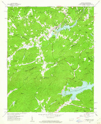
 1965 Hendersonville1967 Print · USGSHenderson County's growth is evident in the mid-1960s as the railroad and highways shaped the valley. Researchers can trace family sites at St Matthews Cem, locate landmarks like the Western NC Fairgrounds, or explore the many summer retreats including Camp Pinnacle.6 unique versions available
 - 1965 Map of Horse Shoe, 1967 Print
 1965 Horse Shoe1967 Print · USGSHenderson County mid-century life is centered on the sweeping curves of the river and the growing community of Etowah. Genealogists and historians can trace family locations through Pleasant Hill Cem, the historic Bowman Bluff settlement, and the early grounds of Camp Kanuga.5 unique versions available
 - 1977 Map of Hendersonville, 1979 Print
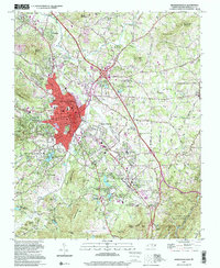
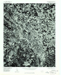 1977 Hendersonville1979 Print · USGSHendersonville and the surrounding Blue Ridge plateau are captured in detail during the late seventies using high-resolution aerial imagery. Trace the urban expansion of Hendersonville and the industrial footprint of East Flat Rock as they appeared decades ago.
 - 1977 Map of Zirconia, 1979 Print
 1977 Zirconia1979 Print · USGSThe mountain borderlands of Henderson County appear in sharp relief during the late seventies. Researchers can trace the sprawling shorelines of Lake Summit and the Poinsett Reservoir to study regional water history and land use.
 - 1986 Map of Hendersonville
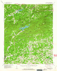
 1986 Hendersonville1986 Print · USGSThe Blue Ridge foothills of North and South Carolina are documented here in the mid-eighties as modern highways began to reshape mountain travel. Local historians can trace the paths of the Southern Railway through Hendersonville or locate landmarks like Looking Glass Rock and Inman Mills.2 unique versions available
 - 1997 Map of Horse Shoe, 2001 Print
 1997 Horse Shoe2001 Print · USGSHenderson County's river-bottom lands and mountain ridges are shown here in the late nineties, centered on the French Broad River. Genealogists can trace family sites like Fletcher Cem and Oak Forest Cem or visit Etowah and Horse Shoe.
 - 1997 Map of Hendersonville, 2001 Print
 1997 Hendersonville2001 Print · USGSHendersonville and its surrounding ridges are captured in the late nineties, showcasing the growth of this mountain community along the Southern Railway. Researchers can trace local lineages through sites like Oakdale Cem, Jones Cem, and schools such as East Henderson High School.
Showing maps 1-25 of 41
Top cities near Flat Rock
- Asheville historical maps
- Greer historical maps
- Hendersonville historical maps
- Fletcher historical maps
- Brevard historical maps
- Mills River historical maps
See more
Top neighborhoods of Flat Rock
- Beaumont historical maps
- Claremont historical maps
- Ravenwood historical maps
- Woodhaven historical maps
- Kingswood historical maps
- Tranquility historical maps
See more
Frequently asked questions
- What are the different types of historical maps available for Flat Rock?
- What is the oldest map of Flat Rock?
- Where can I purchase historical maps of Flat Rock for my home or office?
- Where can I download high-res historical maps of Flat Rock?
- Are there historical topographic maps available for Flat Rock?
- Is there historical aerial imagery available for Flat Rock?
- Where are historical maps of Flat Rock sourced from?