1940s Maps of Tuxedo, North Carolina
Explore 2 historic maps of Tuxedo from the 1940s. These maps offer a rare glimpse into what life looked like during the 1940s — showing old roads, neighborhoods, homes, and landmarks that have changed or disappeared over time.
Whether you're researching your family's past, planning a metal detecting trip, or studying how Tuxedo's landscape evolved across the 1940s, these high-resolution maps are a powerful tool for exploring the history of this region.
- Focus on a specific era: All maps on this page are from the 1940s, giving you a focused view of this time period.
- See what’s changed: Compare century-old streets, trails, and buildings to today's modern landscape using overlays and satellite layers.
- Research with precision: Use these maps for genealogy, historical research, land use analysis, or educational projects.
- View, download, or print: Maps are fully viewable online in high resolution, and can be downloaded or printed for your own records.
Start exploring Tuxedo's history through authentic maps from the 1940s. This is your window into the past.
Tuxedo, NC maps
(2)- 1946 Map of Zirconia, 1957 Print
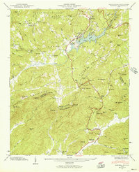 1946 Zirconia1957 Print · USGSThe Blue Ridge and Saluda Mountains come together at the Carolina state line during the mid-1940s. Local researchers can trace family landmarks like Pace Cem, the Fall Creek Sch, and the numerous recreational sites surrounding Lake Summit.4 unique versions available
 - 1947 Map of Zirconia
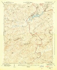 1947 Zirconia1947 Print · USGSCrossing the state line between Henderson and Greenville counties in the late 1940s, this area showcases a landscape of high peaks and hydroelectric development. Researchers can locate family landmarks such as Page Cem, Fall Creek Sch, and the old station at Zirconia.2 unique versions available
End of results
Showing maps 1-2 of 2
Top cities near Tuxedo
- Asheville historical maps
- Greer historical maps
- Hendersonville historical maps
- Fletcher historical maps
- Mills River historical maps
- Flat Rock historical maps
See more
Frequently asked questions
- What are the different types of historical maps available for Tuxedo?
- What is the oldest map of Tuxedo?
- Where can I purchase historical maps of Tuxedo for my home or office?
- Where can I download high-res historical maps of Tuxedo?
- Are there historical topographic maps available for Tuxedo?
- Is there historical aerial imagery available for Tuxedo?
- Where are historical maps of Tuxedo sourced from?