1980s Maps of Iredell County, North Carolina
Explore 5 historic maps of Iredell County from the 1980s. These maps offer a rare glimpse into what life looked like during the 1980s — showing old roads, neighborhoods, homes, and landmarks that have changed or disappeared over time.
Whether you're researching your family's past, planning a metal detecting trip, or studying how Iredell County's landscape evolved across the 1980s, these high-resolution maps are a powerful tool for exploring the history of this region.
- Focus on a specific era: All maps on this page are from the 1980s, giving you a focused view of this time period.
- See what’s changed: Compare century-old streets, trails, and buildings to today's modern landscape using overlays and satellite layers.
- Research with precision: Use these maps for genealogy, historical research, land use analysis, or educational projects.
- View, download, or print: Maps are fully viewable online in high resolution, and can be downloaded or printed for your own records.
Start exploring Iredell County's history through authentic maps from the 1980s. This is your window into the past.
Iredell County, NC maps
(5)- 1984 Map of Winston-Salem, 1985 Print
 1984 Winston-Salem1985 Print · USGSThe North Carolina Piedmont in the mid-1980s shows the growth of Winston-Salem and the busy rail corridors of the Southern Railway. Genealogists and local historians can trace family-named lands and rural communities from Yadkinville to Mount Airy.2 unique versions available
 - 1985 Map of Salisbury, 1986 Print
 1985 Salisbury1986 Print · USGSNorth Carolina’s industrial Piedmont region comes into focus during the mid-eighties as textile and rail towns expanded. Genealogists and historians can locate rural landmarks like Davidson College and Boones Cave State Park or trace the Southern Railway through Lexington and Salisbury.2 unique versions available
 - 1985 Map of Charlotte, 1986 Print
 1985 Charlotte1986 Print · USGSThe Piedmont region in the mid-eighties shows the rapid growth of the Charlotte metro area alongside established textile and college towns. Trace local heritage at the Reed Gold Mine or explore the rail corridors of the Southern Railway and Winston-Salem Southbound Railway.2 unique versions available
 - 1985 Map of Boone, 1986 Print
 1985 Boone1986 Print · USGSThe High Country and Blue Ridge Mountains come into focus during the mid-eighties as Boone and its surrounding wilderness areas undergo modern expansion. Genealogists and historians can trace family-named ridges and landmarks near Appalachian State University, the Cranberry Mines, and Valle Crucis.2 unique versions available
 - 1986 Map of Hickory
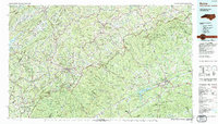
 1986 Hickory1986 Print · USGSWestern North Carolina's foothills are seen here in the mid-eighties as textile and furniture towns flourished along the river. Trace the development of Hickory and Lenoir or locate local landmarks like Burke Chapel, Saw Mills, and Rhodhiss Lake.3 unique versions available
End of results
Showing maps 1-5 of 5
Top cities of Iredell County
- Mooresville historical maps
- Statesville historical maps
- Troutman historical maps
- Harmony historical maps
- Love Valley historical maps
Frequently asked questions
- What are the different types of historical maps available for Iredell County?
- What is the oldest map of Iredell County?
- Where can I purchase historical maps of Iredell County for my home or office?
- Where can I download high-res historical maps of Iredell County?
- Are there historical topographic maps available for Iredell County?
- Is there historical aerial imagery available for Iredell County?
- Where are historical maps of Iredell County sourced from?