1990s Maps of Iredell County, North Carolina
Explore 13 historic maps of Iredell County from the 1990s. These maps offer a rare glimpse into what life looked like during the 1990s — showing old roads, neighborhoods, homes, and landmarks that have changed or disappeared over time.
Whether you're researching your family's past, planning a metal detecting trip, or studying how Iredell County's landscape evolved across the 1990s, these high-resolution maps are a powerful tool for exploring the history of this region.
- Focus on a specific era: All maps on this page are from the 1990s, giving you a focused view of this time period.
- See what’s changed: Compare century-old streets, trails, and buildings to today's modern landscape using overlays and satellite layers.
- Research with precision: Use these maps for genealogy, historical research, land use analysis, or educational projects.
- View, download, or print: Maps are fully viewable online in high resolution, and can be downloaded or printed for your own records.
Start exploring Iredell County's history through authentic maps from the 1990s. This is your window into the past.
Iredell County, NC maps
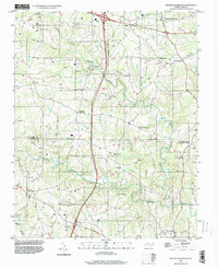
(13)- 1993 Map of Statesville East, 1995 Print
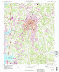
 1993 Statesville East1995 Print · USGSStatesville and its eastern Iredell County environs are captured during a period of significant highway expansion in the early nineties. Researchers can trace historical local sites like the Zion Cem Cameron Ch, Ebenezer Sch, and the old Railroad Grade.
 - 1993 Map of Harmony, 1995 Print
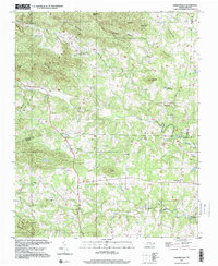
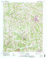 1993 Harmony1995 Print · USGSIredell County's rolling Piedmont landscape is captured here in the mid-1990s, centered on the crossroads of Harmony and Turnersburg. Researchers can trace rural community foundations through local landmarks like North Iredell High Sch, Olin Ch, and the banks of the South Yadkin River.
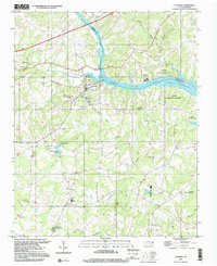
 - 1993 Map of Mooresville, 1996 Print
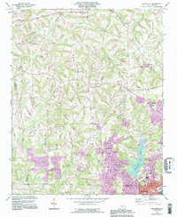
 1993 Mooresville1996 Print · USGSMooresville and the shoreline of Lake Norman are captured in the mid-nineties as the region balanced its textile-town roots with lakeside growth. Researchers can locate family landmarks like Willow Valley Cem, the Dunbar Sch, and Davidson College.
 - 1993 Map of Enochville, 1996 Print
 1993 Enochville1996 Print · USGSThe rural borders of Rowan and Cabarrus counties are captured here in the 1990s as longstanding communities began to expand. Genealogists can locate family landmarks such as McKnight Sch and Pleasant Grove Ch alongside Kannapolis Lake.
 - 1993 Map of Lake Norman North, 1996 Print
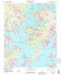 1993 Lake Norman North1996 Print · USGSThe Catawba River valley in the early nineties shows a landscape transformed by reservoir waters and residential growth. Researchers can trace older landmarks like Sherrills Ford and Webbs Chapel or locate the Williamson Cem along the winding shores of Lake Norman.
 - 1993 Map of Troutman, 1996 Print
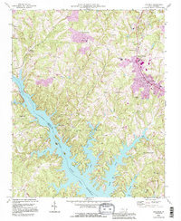 1993 Troutman1996 Print · USGSThe Catawba River valley and the expanding shores of Lake Norman are captured here in the mid-nineties. Researchers can locate long-standing community centers like Barium Springs, the Home for Children, and numerous family-linked sites including Troutman Cem.
 - 1993 Map of Lake Norman South, 1996 Print
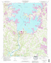 1993 Lake Norman South1996 Print · USGSThe Catawba River valley transitioned into a major recreation hub during the 1990s as suburban growth expanded near the Mecklenburg and Lincoln county lines. Genealogists can locate legacy sites like Ebenezer Cem and Marthas Chapel alongside newer landmarks like Ramsey Creek County Park.
 - 1993 Map of Statesville West, 1996 Print
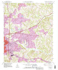
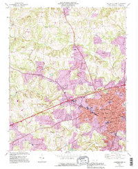 1993 Statesville West1996 Print · USGSIredell County during the mid-1990s reveals a growing urban center in Statesville surrounded by persistent rural settlements. Researchers can trace local heritage through dozens of sites, including Oakwood Cem, Mitchell College, and the community at Loray.
 - 1996 Map of Brooks Crossroads, 2000 Print
 1996 Brooks Crossroads2000 Print · USGSNorth Carolina's Piedmont hills show a blend of old crossroads communities and modern highway development in the mid-nineties. Trace family roots at Wesley Chapel, Brooks Crossroads, or Eagle Mills while following the many branches of Hunting Creek.
 - 1997 Map of Catawba, 2000 Print
 1997 Catawba2000 Print · USGSThe Catawba River valley in the late twentieth century reveals a landscape where historic milling and rural education meet modern recreation. Researchers can locate the Bunker Hill Covered Bridge, the Catawba Rosenwald Sch, and family sites like Smyres Cem.
 - 1997 Map of Cool Springs, 2000 Print
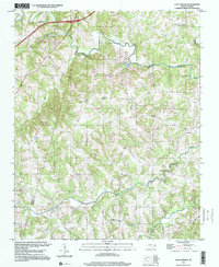 1997 Cool Springs2000 Print · USGSRowan and Iredell counties are captured here in the late nineties, documenting a landscape defined by rolling Piedmont terrain and deep-rooted creek-side settlements. Genealogists can locate family landmarks like Moores Chapel, Providence Cem, and the crossroads at Needmore.
 - 1997 Map of Central, 2000 Print
 1997 Central2000 Print · USGSThe northern hills of Iredell County are shown here in the late 1990s, where the rural character of the Piedmont remains intact. Genealogists can trace family roots through numerous country landmarks like Damascus Ch, Snow Creek Ch, and the community surrounding Love Valley.
 - 1997 Map of Osbornville, 2000 Print
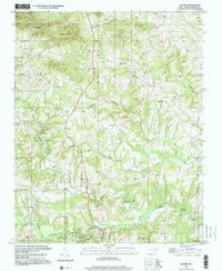
 1997 Osbornville2000 Print · USGSOsbornville and the eastern Brushy Mountains are shown at the end of the century as a network of crossroads communities and highland farms. Genealogists can trace family footprints near Smyrna Chapel, Somers Crossroads, and the rural homes surrounding New Hope.
End of results
Showing maps 1-13 of 13
Top cities of Iredell County
- Mooresville historical maps
- Statesville historical maps
- Troutman historical maps
- Harmony historical maps
- Love Valley historical maps
Frequently asked questions
- What are the different types of historical maps available for Iredell County?
- What is the oldest map of Iredell County?
- Where can I purchase historical maps of Iredell County for my home or office?
- Where can I download high-res historical maps of Iredell County?
- Are there historical topographic maps available for Iredell County?
- Is there historical aerial imagery available for Iredell County?
- Where are historical maps of Iredell County sourced from?