1900s (20th Century) Maps of Iredell County, North Carolina
Explore 49 historic maps of Iredell County from the 1900s (20th Century). These maps offer a rare glimpse into what life looked like during the 1900s — showing old roads, neighborhoods, homes, and landmarks that have changed or disappeared over time.
Whether you're researching your family's past, planning a metal detecting trip, or studying how Iredell County's landscape evolved across the 1900s, these high-resolution maps are a powerful tool for exploring the history of this region.
- Focus on a specific era: All maps on this page are from the 1900s, giving you a focused view of this time period.
- See what’s changed: Compare century-old streets, trails, and buildings to today's modern landscape using overlays and satellite layers.
- Research with precision: Use these maps for genealogy, historical research, land use analysis, or educational projects.
- View, download, or print: Maps are fully viewable online in high resolution, and can be downloaded or printed for your own records.
Start exploring Iredell County's history through authentic maps from the 1900s. This is your window into the past.
Iredell County, NC maps
(49)- 1941 Map of Charlotte
 1941 Charlotte1941 Print · USGSMecklenburg and its surrounding counties are captured here at a pivotal moment in the early 1940s. Genealogists and local historians can trace the rail-driven growth of Charlotte or locate smaller rural landmarks like Alexanders Store, Wesley Chapel, and the community at Stallings.
 - 1942 Map of Charlotte
 1942 Charlotte1942 Print · USGSCharlotte and its surrounding Piedmont communities are captured here during the early years of the Second World War. Researchers can trace the rail corridors of the Southern and Seaboard Air Line or locate family-named sites like Alexanders Store, Hoods Cross Road, and Wesley Chapel.2 unique versions available
 - 1949 Map of Hicks Crossroads
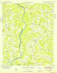 1949 Hicks Crossroads1949 Print · USGSIn the late 1940s, the Catawba River valley still flowed through its original channel, long before the creation of Lake Norman. Local historians can trace the foundations of the Piedmont through rural landmarks like Cowans Ford, Rural Hill Cem, and the cluster of churches at Hicks Crossroads.
 - 1953 Map of Charlotte, 1968 Print
 1953 Charlotte1968 Print · USGSThe North Carolina Piedmont and South Carolina borderlands are shown in detail during a period of significant growth and reservoir development. Trace the rail corridors of the Southern Railway or find family roots in towns like China Grove, Misenheimer, and Lincolnton.3 unique versions available
 - 1953 Map of Winston-Salem, 1974 Print
 1953 Winston-Salem1974 Print · USGSThe North Carolina Piedmont and Virginia highlands meet in the mid-1950s, a landscape defined by the tobacco and textile hubs of the Blue Ridge foothills. Researchers can trace the rail-and-river geography connecting Winston-Salem to mountain towns like Mount Airy and Galax.2 unique versions available
 - 1954 Map of Charlotte
 1954 Charlotte1954 Print · USGSThe North Carolina Piedmont in the mid-1950s shows a region of rapid growth and industrial expansion centered around Charlotte. Trace the era's infrastructure through the Southern railroad lines and locate significant landmarks like the Charlotte Naval Ammunition Depot and Lake Norman.2 unique versions available
 - 1955 Map of Winston-Salem
 1955 Winston-Salem1955 Print · USGSThe Central Blue Ridge and Piedmont transition are captured here in the mid-fifties, from the industrial hub of Winston-Salem to the high peaks of Southwest Virginia. Genealogists can trace family landmarks like Richmond Hill Ch, Siloam Ch, and the old rail stops along the Southern Railway.
 - 1960 Map of Charlotte
 1960 Charlotte1960 Print · USGSMid-century North Carolina and South Carolina meet in this 1960 survey of the Piedmont's industrial and textile heartland. Trace the growth of Charlotte alongside historic landmarks like Kings Mountain National Military Park and the Charlotte Naval Ammunition Depot.2 unique versions available
 - 1962 Map of Winston-Salem
 1962 Winston-Salem1962 Print · USGSThe North Carolina Piedmont meets the Virginia highlands in the early sixties, showing the rail corridors and mountain gaps of the southern Appalachians. Researchers can trace the Blue Ridge Parkway or locate family sites near Winston-Salem, Mount Airy, and Hanging Rock Mountain.
 - 1962 Map of Charlotte
 1962 Charlotte1962 Print · USGSThe North Carolina Piedmont in the early sixties showcases a landscape transformed by massive reservoirs and industrial growth. Researchers can trace the development of Lake Norman, locate the Charlotte Naval Ammunition Depot, or find family landmarks like Wesley Chapel and Brown & Norcott Mills.
 - 1966 Map of Lone Hickory, 1967 Print
 1966 Lone Hickory1967 Print · USGSYadkin and Iredell Counties appear here in the mid-1960s, showing a rural landscape of creek-side farms and historic church communities. Researchers can trace local genealogy through sites like Martins Store, Sandy Springs Ch, and Footville.
 - 1966 Map of Gilreath, 1968 Print
 1966 Gilreath1968 Print · USGSThe foothills of the Blue Ridge come alive in this mid-century portrait of Wilkes and Alexander Counties. Genealogists and historians can trace family roots through numerous country landmarks like New Hope Ch, Old Gilreath, and Hunting Creek Cem.2 unique versions available
 - 1969 Map of Cool Springs, 1972 Print
 1969 Cool Springs1972 Print · USGSThe rural borderlands of Rowan, Iredell, and Davie counties are captured here in the late sixties as the landscape remained defined by small crossroads and river bends. Genealogists can trace family footprints near Moores Chapel, New Jerusalem Ch, and the settlement of Cool Springs.2 unique versions available
 - 1969 Map of Shepherds, 1972 Print
 1969 Shepherds1972 Print · USGSIredell and Rowan counties are captured here in the late sixties, just as the new shoreline of Lake Norman began to alter the rural landscape. Genealogists can trace family footprints through the numerous country churches like Vanderburg Ch and St James Ch, or locate vanished school sites like Amity Sch.
 - 1969 Map of Troutman, 1972 Print
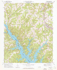 1969 Troutman1972 Print · USGSIredell County is seen here in the late sixties as the rising waters of Lake Norman reshaped the Catawba River valley. Genealogists and local historians can trace the foundations of Troutman and Barium Springs, or locate rural landmarks like Pine Grove Cem and the Home for Children.
 - 1969 Map of Harmony, 1972 Print
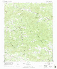
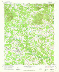
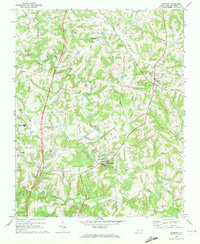 1969 Harmony1972 Print · USGSNorthern Iredell County is shown here in the late sixties, a landscape of Piedmont farmsteads and rural crossroads. Researchers can trace the Old Railroad Grade and locate ancestral sites at Turnersburg, Olin, and Rocky Creek Ch.
 - 1969 Map of Mooresville, 1972 Print
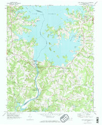
 1969 Mooresville1972 Print · USGSIredell County undergoes significant change in the late sixties as the waters of Lake Norman reach into the western valleys. Genealogists and local historians can trace the foundations of Davidson College and find old landmarks like Centre Ch and Mt Mourne.3 unique versions available
 - 1969 Map of Calahaln, 1972 Print
 1969 Calahaln1972 Print · USGSThe rural Piedmont of Davie and Iredell counties appears here in the late sixties as a landscape of established crossroads and country churches. Researchers can locate small family-named landmarks like Ijames Crossroads or congregations at Rock Spring Ch and Piney Grove Ch.2 unique versions available
 - 1969 Map of Statesville West, 1972 Print
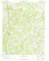
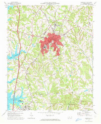
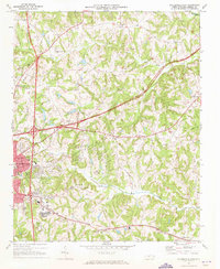
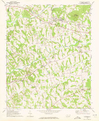
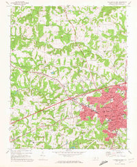 1969 Statesville West1972 Print · USGSIredell County during the late sixties shows the westward expansion of a key North Carolina hub as it moves into the surrounding countryside. Genealogists can trace family roots through numerous local landmarks like Midway Ch Cem, Mitchell College, and the community of Loray.
 - 1969 Map of Central, 1972 Print
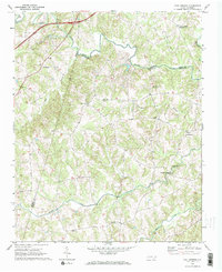
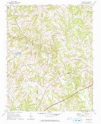
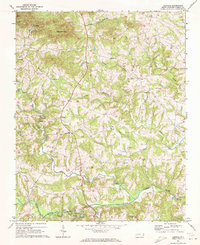 1969 Central1972 Print · USGSIredell County's rural communities are preserved here in the late sixties as the area maintained its traditional agricultural character. Genealogists can locate family landmarks like Keaton Grove Ch, the Central Sch, and the unique settlement of Love Valley.
 - 1969 Map of Statesville East, 1973 Print
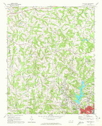
 1969 Statesville East1973 Print · USGSIredell County during the late 1960s shows the growth of Statesville at the crossroads of new interstates and the historic Southern railroad. Genealogists and local historians can locate long-standing rural hubs like Belmont Cem, Bethany Ch, and Unity High Sch.
 - 1970 Map of Enochville, 1972 Print
 1970 Enochville1972 Print · USGSRowan and Cabarrus counties in the early seventies reveal a landscape of rural congregations and emerging utility networks. Researchers can trace family history through numerous landmarks like St Pauls Ch, McKnight Sch, and the community at Enochville.
 - 1970 Map of Hiddenite, 1972 Print
 1970 Hiddenite1972 Print · USGSAlexander County’s rolling hills and river valleys are captured here in the early 1970s, centered on the community of Hiddenite. Researchers can locate numerous rural landmarks including Linneys Grove Ch, the Quarry at Rocky Face, and the Zion Chapel Cem.
 - 1970 Map of Lake Norman South, 1972 Print
 1970 Lake Norman South1972 Print · USGSMecklenburg County enters the seventies as a newly created lakeside community following the damming of the Catawba River. Genealogists and historians can trace the local landscape through landmarks like Triangle Sch, the Seaboard Coast Line rail, and Allison Ferry.2 unique versions available
 - 1970 Map of Cleveland, 1972 Print
 1970 Cleveland1972 Print · USGSRowan County in the early seventies centers on the rail-side community of Cleveland and the rural crossroads of Mount Ulla. Genealogists and historians can trace the foundations of the community through Thyatira Ch, Mill Bridge, and Knox Chapel.2 unique versions available
Showing maps 1-25 of 49
Top cities of Iredell County
- Mooresville historical maps
- Statesville historical maps
- Troutman historical maps
- Harmony historical maps
- Love Valley historical maps
Frequently asked questions
- What are the different types of historical maps available for Iredell County?
- What is the oldest map of Iredell County?
- Where can I purchase historical maps of Iredell County for my home or office?
- Where can I download high-res historical maps of Iredell County?
- Are there historical topographic maps available for Iredell County?
- Is there historical aerial imagery available for Iredell County?
- Where are historical maps of Iredell County sourced from?