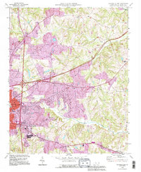
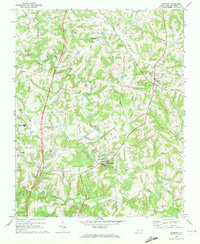
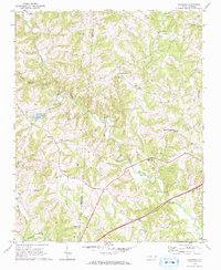
1993 Map of Statesville East
USGS Topo · Published 1995About this map
Statesville serves as the focal point of this Iredell County landscape, which underwent significant infrastructure updates by the early 1990s. The convergence of Interstate 40 and Interstate 77 is clearly documented through series of interchanges, including Interchange 154 and Interchange 51 A-B, reflecting the town's growth as a regional transportation hub. Despite this modernization, the map preserves the deep-rooted religious and educational geography of the area, featuring numerous country churches and schools such as Bethany Ch, Providence Ch, and Unity High Sch. The rural landscape to the east is defined by the winding paths of Fourth Creek and Fifth Creek, where small settlements like Elmwood and the Mobile Home Park are situated. Notable institutional landmarks like the State Correctional Center and the Statesville Country Club provide a clear view of the varied land use patterns transitioning from the urban center to the surrounding farmland.
Find a feature on this map
47 named features on this map. Tap any name to fly to it.
Don’t see what you’re looking for? This feature index may not catch every label — zoom into the map to look around manually.
Map Details
Editions of this 1993 Statesville East Map
This is the sole edition of this map. No revisions or reprints were ever made.
Other maps of this area

1893 · Statesville
USGS Topo · 1:125,000

1953 · Charlotte
USGS Topo · 1:250,000

1954 · Charlotte
USGS Topo · 1:250,000

1960 · Charlotte
USGS Topo · 1:250,000

1962 · Charlotte
USGS Topo · 1:250,000
1969 · Cool Springs
USGS Topo · 1:24,000
1969 · Shepherds
USGS Topo · 1:24,000
1969 · Troutman
USGS Topo · 1:24,000
1969 · Harmony
USGS Topo · 1:24,000
1969 · Calahaln
USGS Topo · 1:24,000