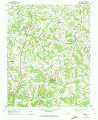
1969 Map of Harmony
USGS Topo · Published 1972About this map
Rocky Creek and Dutchman Creek wind through the rolling landscape of northern Iredell County, converging toward the South Yadkin River at the bottom of the map. The settlement of Harmony serves as a local hub near several water tanks, while smaller communities like Williamsburg, Olin, and Turnersburg are linked by a network of rural roads and the traces of an Old Railroad Grade. This 1969 field-checked survey reveals a deeply rooted rural society defined by its numerous country churches, including Macedonia Ch, Mt Bethel Ch, and New Hope Ch. The presence of the North Iredell High Sch and several substations indicates the infrastructure serving these dispersed farming communities during the late 1960s. Genealogists will find particular value in the scattered cemeteries and family-named landmarks such as Camel Branch and Patterson.
Find a feature on this map
35 named features on this map. Tap any name to fly to it.
Don’t see what you’re looking for? This feature index may not catch every label — zoom into the map to look around manually.
Map Details
Editions of this 1969 Harmony Map
This is the sole edition of this map. No revisions or reprints were ever made.
Other maps of this area

1891 · Yadkinville
USGS Topo · 1:125,000

1893 · Statesville
USGS Topo · 1:125,000

1893 · Yadkinville
USGS Topo · 1:125,000

1953 · Charlotte
USGS Topo · 1:250,000

1953 · Winston-Salem
USGS Topo · 1:250,000

1954 · Charlotte
USGS Topo · 1:250,000

1955 · Winston-Salem
USGS Topo · 1:250,000

1960 · Charlotte
USGS Topo · 1:250,000

1962 · Winston-Salem
USGS Topo · 1:250,000

1962 · Charlotte
USGS Topo · 1:250,000