1940s Maps of Jackson County, North Carolina
Explore 26 historic maps of Jackson County from the 1940s. These maps offer a rare glimpse into what life looked like during the 1940s — showing old roads, neighborhoods, homes, and landmarks that have changed or disappeared over time.
Whether you're researching your family's past, planning a metal detecting trip, or studying how Jackson County's landscape evolved across the 1940s, these high-resolution maps are a powerful tool for exploring the history of this region.
- Focus on a specific era: All maps on this page are from the 1940s, giving you a focused view of this time period.
- See what’s changed: Compare century-old streets, trails, and buildings to today's modern landscape using overlays and satellite layers.
- Research with precision: Use these maps for genealogy, historical research, land use analysis, or educational projects.
- View, download, or print: Maps are fully viewable online in high resolution, and can be downloaded or printed for your own records.
Start exploring Jackson County's history through authentic maps from the 1940s. This is your window into the past.
Jackson County, NC maps
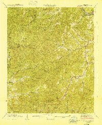
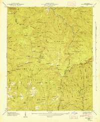
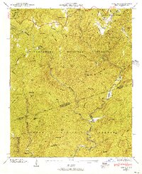
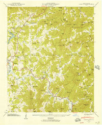
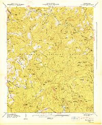
(26)- 1940 Map of Whittier
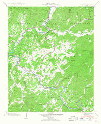 1940 Whittier1940 Print · USGSWestern North Carolina's high mountain valleys and Cherokee lands are meticulously documented in the years before mid-century. Genealogists and local historians can trace family locations near Whittier, the Cherokee Indian Sch, and numerous mountain burial sites like Union Hill Cem.2 unique versions available
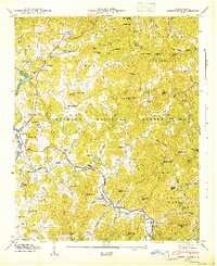
 - 1940 Map of Greens Creek, 1957 Print
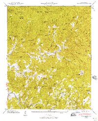
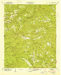
 1940 Greens Creek1957 Print · USGSIn the early 1940s, these North Carolina mountain communities were connected by high gaps and winding creek forks. Local historians can trace the foundations of Pumpkintown or locate rural landmarks like Greens Creek Sch and the Lookout Tower on Cowee Bald.6 unique versions available
 - 1941 Map of Addie
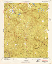
 1941 Addie1941 Print · USGSJackson County's mountain settlements and rail corridors are captured here just before the mid-century, centered on the Southern railroad route. Researchers can trace family sites like Norman Cem or locate community centers at Liberty Sch and Ochre Hill Ch.2 unique versions available
 - 1941 Map of Whittier
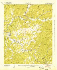 1941 Whittier1941 Print · USGSThe Tuckasegee and Oconaluftee rivers converge in this pre-war survey of Jackson and Swain Counties. Local historians can trace the Southern railroad line through Whittier or locate family roots at Union Hill Cem and the Cherokee Indian Sch.2 unique versions available
 - 1941 Map of Greens Creek
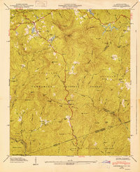
 1941 Greens Creek1941 Print · USGSJackson County and the edges of the Great Smokies are captured here just before the mid-century, centered on the Tuckasegee River corridor. Researchers can locate early mountain schools and churches like Greens Creek School, Gay, and the Eagle Cem.
 - 1941 Map of Hazelwood, 1957 Print
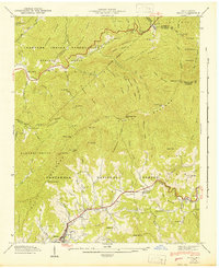
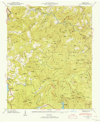
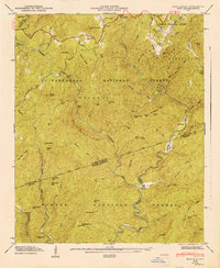
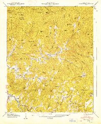
 1941 Hazelwood1957 Print · USGSThe high passes of the Plott Balsams were a vital rail and road corridor in the early 1940s. Genealogists and historians can trace the foundations of Hazelwood and Balsam, finding remote sites like the Grassy Ridge Mine and Redbank Cem.7 unique versions available
 - 1942 Map of Addie
 1942 Addie1942 Print · USGSJackson County's mountain communities and the Southern railroad corridor are captured here in the early 1940s. Researchers can locate family landmarks like Norman Cem or trace the early development of Sylva, Addie, and Willits.
 - 1942 Map of Hazelwood
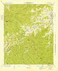 1942 Hazelwood1942 Print · USGSThe mountain communities around WAYNESVILLE and Hazelwood are shown just before the mid-century during this era of rail travel and early industry. Trace family sites at the Allen Creek Sch or search for local landmarks like the Grassy Ridge Mine and Redbank Cem.
 - 1946 Map of Cullowhee, 1947 Print
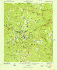
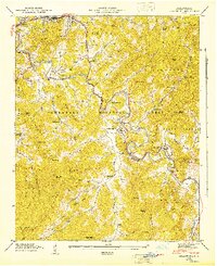 1946 Cullowhee1947 Print · USGSThe Tuckasegee River valley thrives shortly after the war, centered on the campus of Western Carolina Teachers College and the railroad hub at Sylva. Genealogists and historians can trace old homesteads and family burials at Parris Cem, Stillwell Cem, and the settlement at East Laport.8 unique versions available
 - 1946 Map of Sam Knob, 1947 Print
 1946 Sam Knob1947 Print · USGSThe high peaks of the Blue Ridge Mountains are captured here just after the war, showing the wild intersection of three North Carolina counties. Researchers can locate remote landmarks like the Charley Creek Sch, Courthouse Falls, and the winding Blue Ridge Parkway.7 unique versions available
 - 1946 Map of Highlands, 1954 Print
 1946 Highlands1954 Print · USGSHighlands and the surrounding Nantahala heights are captured here just after the war, showing the mountain town alongside its developing reservoirs and backcountry roads. Genealogists and hikers can trace old landmarks like Clear Creek School, Horse Cove Cemetery, and the cascades of Dry Falls.5 unique versions available
 - 1946 Map of Glenville, 1956 Print
 1946 Glenville1956 Print · USGSThe high country of Jackson and Macon counties is surveyed here just after the war, showing the newly formed Glenville Lake. Researchers can trace rural settlements like Erastus, family plots at Strain Cem, and the old Whiterock Sch.7 unique versions available
 - 1946 Map of Lake Toxaway, 1956 Print
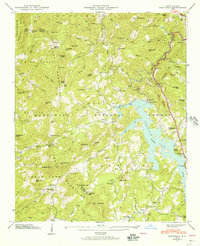
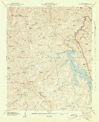
 1946 Lake Toxaway1956 Print · USGSTransylvania and Jackson counties are captured in the late 1940s, highlighting the mountainous terrain of the Nantahala National Forest and Pisgah National Forest. Researchers can locate family landmarks like the Mc Call Cem, Tennessee Gap Sch, and the community at Quebec.4 unique versions available
 - 1946 Map of Reid, 1956 Print
 1946 Reid1956 Print · USGSThe high mountain country of the Blue Ridge is documented here in the mid-1940s, just as the national forests were maturing. Genealogists and hikers can trace the remote Oakland Cem, the tiny settlement of Cane Brake, and the old rail path of the Southern Railway.4 unique versions available
 - 1946 Map of Tuckasegee, 1957 Print
 1946 Tuckasegee1957 Print · USGSThe West Fork of the Tuckasegee River valley is shown here in the mid-1940s, a landscape defined by small mountain settlements and the emerging Nantahala National Forest. Genealogists can locate family sites like Stephenson Cem and Brasstown Cem alongside the Caney Fork Sch.5 unique versions available
 - 1946 Map of Big Ridge, 1957 Print
 1946 Big Ridge1957 Print · USGSNorth Carolina's high Jackson County timberlands are captured here in the mid-1940s as the Tennessee Valley Authority surveyed these steep river headwaters. Genealogists can locate family-named landmarks like Rock Bridge Sch, Big Ridge Ch, and the high waters of Glenville Lake.5 unique versions available
 - 1946 Map of Cashiers, 1957 Print
 1946 Cashiers1957 Print · USGSJackson County high country comes alive in the mid-1940s, showcasing the intersection of the Blue Ridge and the Tennessee Divide. Genealogists and historians can locate family landmarks like Upper Zachary Cem, Montvale Sch, and the community of Grimshawes.5 unique versions available
 - 1946 Map of Corbin Knob, 1957 Print
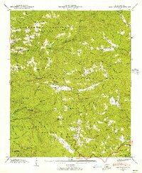
 1946 Corbin Knob1957 Print · USGSMacon County mountain life is detailed here just after the war, showing the area surrounding the town of Franklin. Genealogists can locate family landmarks including Anbel Cem, Sloans Chapel, and early schools like Walnut Creek Sch.6 unique versions available
 - 1947 Map of Reid
 1947 Reid1947 Print · USGSThe Blue Ridge mountains at the North and South Carolina border are captured here in the late 1940s, showing a land defined by national forests and river gorges. Researchers can locate the Oakland Cem, trace the Thompson River, and find remote landmarks like Musterground Mtn.
 - 1947 Map of Lake Toxaway
 1947 Lake Toxaway1947 Print · USGSTransylvania and Jackson counties are captured just after the war when mountain life revolved around isolated schools and churches. Genealogists can locate family landmarks like the McCall Cem, Tennessee Gap Sch, and the community of Quebec.
 - 1947 Map of Cashiers
 1947 Cashiers1947 Print · USGSThe Blue Ridge high country of Jackson County is meticulously detailed here in the late 1940s, centered on the Cashiers plateau. Genealogists can locate family sites like Upper Zachary Cem, the rural Montvale Sch, and the remote junction at Ellicott Rock.2 unique versions available
 - 1947 Map of Big Ridge
 1947 Big Ridge1947 Print · USGSJackson County is documented here in the late 1940s, highlighting the isolated settlements and mountain watersheds of the Blue Ridge. Genealogists and local historians can locate Big Ridge Ch, the Rock Bridge Sch, and family-named landmarks like Lizzie Mountain or Henderson Mtn.
 - 1947 Map of Glenville
 1947 Glenville1947 Print · USGSJackson County and the Tuckasegee River valley are captured here shortly after the war, showing a landscape reshaped by hydroelectric development. Researchers can locate remote mountain landmarks such as Whiterock Sch, Erastus Cem, and the Lookout Tower on Yellow Mountain.2 unique versions available
 - 1947 Map of Corbin Knob
 1947 Corbin Knob1947 Print · USGSMacon County in the late 1940s reveals a mountain landscape of deep river valleys and family-named peaks within the Nantahala National Forest. Researchers can trace rural school systems at Oak Ridge Sch and Higdon Sch or locate the ancient Nikwasi Indian Mound.2 unique versions available
 - 1947 Map of Tuckasegee
 1947 Tuckasegee1947 Print · USGSJackson County's mountain communities were still largely defined by family homesteads and valley schools just after the war. Genealogists can trace family names through landmarks like Stephenson Cem, the Judaculla Rock, and the rural Caney Fork Sch.2 unique versions available
Showing maps 1-25 of 26
Top cities of Jackson County
- Cullowhee historical maps
- Sylva historical maps
- Webster historical maps
- Forest Hills historical maps
- Dillsboro historical maps
- Cashiers historical maps
Frequently asked questions
- What are the different types of historical maps available for Jackson County?
- What is the oldest map of Jackson County?
- Where can I purchase historical maps of Jackson County for my home or office?
- Where can I download high-res historical maps of Jackson County?
- Are there historical topographic maps available for Jackson County?
- Is there historical aerial imagery available for Jackson County?
- Where are historical maps of Jackson County sourced from?