1990s Maps of Jackson County, North Carolina
Explore 6 historic maps of Jackson County from the 1990s. These maps offer a rare glimpse into what life looked like during the 1990s — showing old roads, neighborhoods, homes, and landmarks that have changed or disappeared over time.
Whether you're researching your family's past, planning a metal detecting trip, or studying how Jackson County's landscape evolved across the 1990s, these high-resolution maps are a powerful tool for exploring the history of this region.
- Focus on a specific era: All maps on this page are from the 1990s, giving you a focused view of this time period.
- See what’s changed: Compare century-old streets, trails, and buildings to today's modern landscape using overlays and satellite layers.
- Research with precision: Use these maps for genealogy, historical research, land use analysis, or educational projects.
- View, download, or print: Maps are fully viewable online in high resolution, and can be downloaded or printed for your own records.
Start exploring Jackson County's history through authentic maps from the 1990s. This is your window into the past.
Jackson County, NC maps
(6)- 1997 Map of Sam Knob, 2001 Print
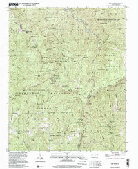 1997 Sam Knob2001 Print · USGSHigh-altitude ridges and wilderness areas dominate this portion of the Blue Ridge in the late twentieth century. Hikers and historians can trace the Blue Ridge Parkway as it bypasses Richland Balsam and find landmarks like Courthouse Falls and Devils Courthouse.
 - 1997 Map of Cashiers, 2001 Print
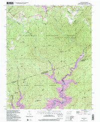
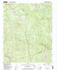 1997 Cashiers2001 Print · USGSThe Blue Ridge high country near the turn of the millennium shows a landscape of deep family roots and protected wilderness. Genealogists can trace local history through sites like Upper Zachary Cem, Heady Mountain Ch, and the settlement at Bohaynee.
 - 1997 Map of Hazelwood, 2001 Print
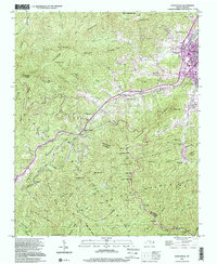 1997 Hazelwood2001 Print · USGSThe high ridges of the Great Balsam Mountains meet the growing towns of Waynesville and Hazelwood in the late 1990s. Researchers can trace the local landscape through landmarks like Grassy Ridge Mine, Redbank Cem, and the Morrison Fish Hatchery.
 - 1997 Map of Tuckasegee, 2001 Print
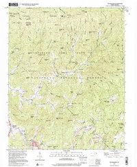 1997 Tuckasegee2001 Print · USGSWestern North Carolina mountain life is preserved here as it appeared in the late nineties. Genealogists and historians can trace family locations through numerous sites like Woodring Cem, Catherine Chapel, and the community of Tuckasegee.
 - 1997 Map of Reid, 2001 Print
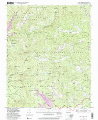
 1997 Reid2001 Print · USGSThe Blue Ridge high country is captured here in the late nineties, documenting the rugged borderlands between North and South Carolina. Researchers can trace family sites near Oakland, find the Oakland Cem, and locate landmarks like Toxaway Falls.
 - 1997 Map of Lake Toxaway, 2001 Print
 1997 Lake Toxaway2001 Print · USGSThe high country of Transylvania and Jackson counties is captured here in the late twentieth century, centered on the waters of Lake Toxaway. Researchers can trace old family sites and mountain congregations at Wolf Mountain Ch, Owens Cem, and the settlement of Quebec.
End of results
Showing maps 1-6 of 6
Top cities of Jackson County
- Cullowhee historical maps
- Sylva historical maps
- Webster historical maps
- Forest Hills historical maps
- Dillsboro historical maps
- Cashiers historical maps
Frequently asked questions
- What are the different types of historical maps available for Jackson County?
- What is the oldest map of Jackson County?
- Where can I purchase historical maps of Jackson County for my home or office?
- Where can I download high-res historical maps of Jackson County?
- Are there historical topographic maps available for Jackson County?
- Is there historical aerial imagery available for Jackson County?
- Where are historical maps of Jackson County sourced from?