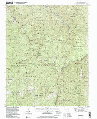
1997 Map of Sam Knob
USGS Topo · Published 2001About this map
Richland Balsam towers over this high-elevation landscape where the Blue Ridge Parkway winds through the heart of the Southern Appalachians. Mapping by the Tennessee Valley Authority and the U.S. Geological Survey reveals a complex network of ridges and water gaps at the junction of Haywood, Jackson, and Transylvania counties. The area is defined by massive tracts of public land, including the Nantahala National Forest and the Shining Rock Wilderness Area, which preserve the headwaters of the West Fork Pigeon River and the Nantahala River. This terrain is punctuated by distinctive geological features like Devils Courthouse and waterfalls such as Courthouse Falls and Dill Falls. The dense concentration of named knobs and gaps, from Reinhart Knob to Buck Knob, illustrates a wilderness largely untouched by industrial development, managed instead for conservation and recreation through the Pisgah Game Land.
Find a feature on this map
117 named features on this map. Tap any name to fly to it.
Don’t see what you’re looking for? This feature index may not catch every label — zoom into the map to look around manually.
Map Details
Editions of this 1997 Sam Knob Map
This is the sole edition of this map. No revisions or reprints were ever made.
Other maps of this area

1891 · Cowee
USGS Topo · 1:125,000

1897 · Cowee
USGS Topo · 1:125,000

1905 · Pisgah
USGS Topo · 1:125,000

1906 · Pisgah
USGS Topo · 1:125,000

1907 · Cowee
USGS Topo · 1:125,000

1935 · Cruso
USGS Topo · 1:24,000

1935 · Waynesville
USGS Topo · 1:24,000

1935 · Sam Knob
USGS Topo · 1:24,000

1935 · Rosman
USGS Topo · 1:24,000

1935 · Tuckaseigee
USGS Topo · 1:24,000