1990s Maps of Hardee Cross Roads, North Carolina
Explore 1 historic maps of Hardee Cross Roads from the 1990s. These maps offer a rare glimpse into what life looked like during the 1990s — showing old roads, neighborhoods, homes, and landmarks that have changed or disappeared over time.
Whether you're researching your family's past, planning a metal detecting trip, or studying how Hardee Cross Roads's landscape evolved across the 1990s, these high-resolution maps are a powerful tool for exploring the history of this region.
- Focus on a specific era: All maps on this page are from the 1990s, giving you a focused view of this time period.
- See what’s changed: Compare century-old streets, trails, and buildings to today's modern landscape using overlays and satellite layers.
- Research with precision: Use these maps for genealogy, historical research, land use analysis, or educational projects.
- View, download, or print: Maps are fully viewable online in high resolution, and can be downloaded or printed for your own records.
Start exploring Hardee Cross Roads's history through authentic maps from the 1990s. This is your window into the past.
Hardee Cross Roads, NC maps
(1)- 1997 Map of Benson, 2000 Print
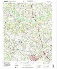 1997 Benson2000 Print · USGSBenson and its rural surroundings in Johnston County were undergoing modern development during the late nineties. Researchers can find numerous family-named sites and country churches, including Hardee Cross Roads, Stevens Chapel, and Hannah Creek Ch.
End of results
Showing maps 1-1 of 1
Top cities near Hardee Cross Roads
- Cary historical maps
- Apex historical maps
- Fuquay-Varina historical maps
- Clayton historical maps
- Garner historical maps
- Holly Springs historical maps
See more
Frequently asked questions
- What are the different types of historical maps available for Hardee Cross Roads?
- What is the oldest map of Hardee Cross Roads?
- Where can I purchase historical maps of Hardee Cross Roads for my home or office?
- Where can I download high-res historical maps of Hardee Cross Roads?
- Are there historical topographic maps available for Hardee Cross Roads?
- Is there historical aerial imagery available for Hardee Cross Roads?
- Where are historical maps of Hardee Cross Roads sourced from?