1990s Maps of Smithfield, North Carolina
Explore 5 historic maps of Smithfield from the 1990s. These maps offer a rare glimpse into what life looked like during the 1990s — showing old roads, neighborhoods, homes, and landmarks that have changed or disappeared over time.
Whether you're researching your family's past, planning a metal detecting trip, or studying how Smithfield's landscape evolved across the 1990s, these high-resolution maps are a powerful tool for exploring the history of this region.
- Focus on a specific era: All maps on this page are from the 1990s, giving you a focused view of this time period.
- See what’s changed: Compare century-old streets, trails, and buildings to today's modern landscape using overlays and satellite layers.
- Research with precision: Use these maps for genealogy, historical research, land use analysis, or educational projects.
- View, download, or print: Maps are fully viewable online in high resolution, and can be downloaded or printed for your own records.
Start exploring Smithfield's history through authentic maps from the 1990s. This is your window into the past.
Smithfield, NC maps
(5)- 1990 Map of Raleigh, 1991 Print
 1990 Raleigh1991 Print · USGSGreater Raleigh and the Research Triangle entered a period of significant suburban growth during the 1990s. Researchers can trace the development of towns like Fuquay-Varina and Wake Forest or locate landmarks such as the State Prison and Harris Reservoir.2 unique versions available
 - 1993 Map of Powhatan, 1999 Print
 1993 Powhatan1999 Print · USGSCoastal plain communities south of Powhatan are shown here in the 1990s as the area transitioned between rural farmland and suburban growth. Genealogists and historians can trace local landmarks like Short Journey Sch, Powhatan Ch, and Whitley Heights.
 - 1997 Map of Four Oaks NE, 2000 Print
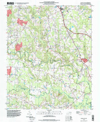
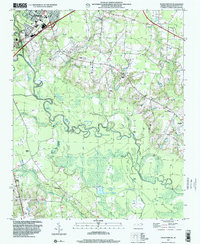 1997 Four Oaks NE2000 Print · USGSThe riverfront and rural outskirts of Johnston County come alive in the late nineties, where the winding Neuse River meets the growing edge of Smithfield. Researchers can trace the location of numerous country churches and landmarks like Sanders Chapel, The Cowbone, and Polecat Landing.
 - 1997 Map of Four Oaks, 2000 Print
 1997 Four Oaks2000 Print · USGSFour Oaks and its surrounding Johnston County farmland are captured here in the late nineties as the region balanced its rural roots with growing highway infrastructure. Genealogists can trace family footprints at Barbour Chapel, Keen Cem Park, and the crossroads at Allens Crossroads.
 - 1998 Map of Selma, 2000 Print
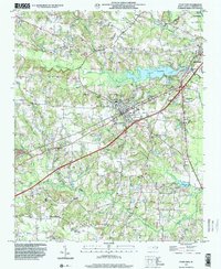
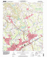 1998 Selma2000 Print · USGSThe Johnston County corridor at the close of the century shows a landscape where historic rural settlements meet modern regional infrastructure. Genealogists can trace family landmarks like Lassiter Cem and Yelverton Grove Ch alongside civic hubs like the Johnston County Hospital.
End of results
Showing maps 1-5 of 5
Top cities near Smithfield
- Raleigh historical maps
- Clayton historical maps
- Garner historical maps
- Dunn historical maps
- Selma historical maps
- Benson historical maps
See more
Top neighborhoods of Smithfield
- Castlehaven historical maps
- Fairfield historical maps
- Laurelwood Hills historical maps
- Sunrise Acres historical maps
- West Smithfield historical maps
- Westview historical maps
See more
Frequently asked questions
- What are the different types of historical maps available for Smithfield?
- What is the oldest map of Smithfield?
- Where can I purchase historical maps of Smithfield for my home or office?
- Where can I download high-res historical maps of Smithfield?
- Are there historical topographic maps available for Smithfield?
- Is there historical aerial imagery available for Smithfield?
- Where are historical maps of Smithfield sourced from?