1960s Maps of Wilsons Mills, North Carolina
Explore 3 historic maps of Wilsons Mills from the 1960s. These maps offer a rare glimpse into what life looked like during the 1960s — showing old roads, neighborhoods, homes, and landmarks that have changed or disappeared over time.
Whether you're researching your family's past, planning a metal detecting trip, or studying how Wilsons Mills's landscape evolved across the 1960s, these high-resolution maps are a powerful tool for exploring the history of this region.
- Focus on a specific era: All maps on this page are from the 1960s, giving you a focused view of this time period.
- See what’s changed: Compare century-old streets, trails, and buildings to today's modern landscape using overlays and satellite layers.
- Research with precision: Use these maps for genealogy, historical research, land use analysis, or educational projects.
- View, download, or print: Maps are fully viewable online in high resolution, and can be downloaded or printed for your own records.
Start exploring Wilsons Mills's history through authentic maps from the 1960s. This is your window into the past.
Wilsons Mills, NC maps
(3)- 1964 Map of Selma, 1965 Print
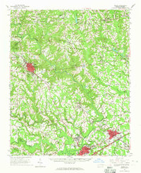 1964 Selma1965 Print · USGSEastern Johnston County flourished as a rail and river hub in the mid-sixties, dominated by the crossing of the Neuse River. Researchers can trace old family sites and crossroads from Archers Lodge to Pine Level, including the Harrison High Sch and Branch Chapel.
 - 1964 Map of Powhatan, 1965 Print
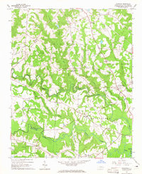 1964 Powhatan1965 Print · USGSJohnston County's rural landscape is captured here in the mid-sixties, showing a community organized around country churches and winding creek bottoms. Researchers can trace family sites near Elizabeth Ch, Short Journey Sch, and the Southern railroad line.3 unique versions available
 - 1964 Map of Selma, 1965 Print
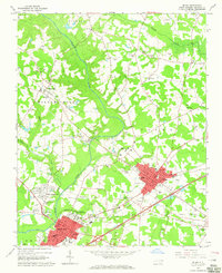 1964 Selma1965 Print · USGSJohnston County in the mid-sixties reveals a landscape shaped by the Neuse River and a dense network of railroads. Researchers can trace family history through dozens of rural sites like Richardson Cem, New Hill Ch, and the County Training Sch.3 unique versions available
End of results
Showing maps 1-3 of 3
Top cities near Wilsons Mills
- Raleigh historical maps
- Clayton historical maps
- Garner historical maps
- Smithfield historical maps
- Wendell historical maps
- Zebulon historical maps
See more
Top neighborhoods of Wilsons Mills
Frequently asked questions
- What are the different types of historical maps available for Wilsons Mills?
- What is the oldest map of Wilsons Mills?
- Where can I purchase historical maps of Wilsons Mills for my home or office?
- Where can I download high-res historical maps of Wilsons Mills?
- Are there historical topographic maps available for Wilsons Mills?
- Is there historical aerial imagery available for Wilsons Mills?
- Where are historical maps of Wilsons Mills sourced from?