1940s Maps of Beech Glen, North Carolina
Explore 2 historic maps of Beech Glen from the 1940s. These maps offer a rare glimpse into what life looked like during the 1940s — showing old roads, neighborhoods, homes, and landmarks that have changed or disappeared over time.
Whether you're researching your family's past, planning a metal detecting trip, or studying how Beech Glen's landscape evolved across the 1940s, these high-resolution maps are a powerful tool for exploring the history of this region.
- Focus on a specific era: All maps on this page are from the 1940s, giving you a focused view of this time period.
- See what’s changed: Compare century-old streets, trails, and buildings to today's modern landscape using overlays and satellite layers.
- Research with precision: Use these maps for genealogy, historical research, land use analysis, or educational projects.
- View, download, or print: Maps are fully viewable online in high resolution, and can be downloaded or printed for your own records.
Start exploring Beech Glen's history through authentic maps from the 1940s. This is your window into the past.
Beech Glen, NC maps
(2)- 1945 Map of Mars Hill, 1957 Print
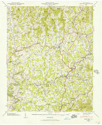 1945 Mars Hill1957 Print · USGSMadison and Buncombe counties are captured in the mid-1940s, showing a landscape of high ridges and deep hollows before modern development. Genealogists can trace family landmarks and rural community centers like Old Bull Creek Ch, Ivy (PO), and the George Cem.4 unique versions available
 - 1946 Map of Mars Hill, 1947 Print
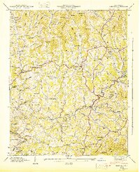 1946 Mars Hill1947 Print · USGSMadison and Buncombe counties come into sharp focus in the mid-1940s, showing a landscape of tight-knit mountain hollows and rural post offices. Genealogists can trace family roots through dozens of sites like Sams Cem, Gabriel Creek Ch, and the Ivy Post Office.
End of results
Showing maps 1-2 of 2
Top cities near Beech Glen
- Asheville historical maps
- Black Mountain historical maps
- Swannanoa historical maps
- Woodfin historical maps
- Weaverville historical maps
- Mars Hill historical maps
See more
Frequently asked questions
- What are the different types of historical maps available for Beech Glen?
- What is the oldest map of Beech Glen?
- Where can I purchase historical maps of Beech Glen for my home or office?
- Where can I download high-res historical maps of Beech Glen?
- Are there historical topographic maps available for Beech Glen?
- Is there historical aerial imagery available for Beech Glen?
- Where are historical maps of Beech Glen sourced from?