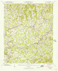
1945 Map of Mars Hill
USGS Topo · Published 1957About this map
Mars Hill serves as the focal point of this mid-century survey, situated at the intersection of several mountain ridges near the boundary of Madison and Buncombe counties. The landscape is defined by the steep drainage basins of Ivy Creek and Bull Creek, where narrow hollows and ridge-lines dictated the placement of early homesteads and community centers. Local history is deeply etched into the topography through a high density of family-named landmarks and cemeteries, such as the Buckner Cem and Ramsey Cem, alongside rural social hubs like Peek Chapel and Old Bull Creek Ch.
Find a feature on this map
118 named features on this map. Tap any name to fly to it.
Don’t see what you’re looking for? This feature index may not catch every label — zoom into the map to look around manually.
Map Details
Editions of this 1945 Mars Hill Map
4 editions found
Other maps of this area

1894 · Asheville
USGS Topo · 1:125,000

1900 · Mount Mitchell
USGS Topo · 1:125,000

1901 · Asheville
USGS Topo · 1:125,000

1902 · Mount Mitchell
USGS Topo · 1:125,000

1935 · Bald Creek
USGS Topo · 1:24,000

1935 · Barnardsville
USGS Topo · 1:24,000

1935 · Craggy Pinnacle
USGS Topo · 1:24,000

1936 · Marshall
USGS Topo · 1:24,000

1936 · Sams Gap
USGS Topo · 1:24,000

1936 · White Rock
USGS Topo · 1:24,000