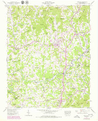
1945 Map of Mars Hill
USGS Topo · Published 1979About this map
Mars Hill sits at the heart of this Appalachian landscape, serving as a focal point for the surrounding rural communities during the mid-20th century. The settlement pattern is defined by the complex drainage of Ivy Creek and Little Ivy Creek, where family-named cemeteries such as Sams Cem, Ray Cem, and Dill Cem document the deep genealogical roots of the region. This 1945 data, updated in the late 1970s, illustrates the institutional backbone of these mountain valleys, anchored by Old Bull Creek Ch, Gabriel Creek Ch, and Center Sch. The terrain is marked by significant elevations like Middle Mountain Ridge and Beech Glen, which hem in the smaller settlements of Petersburg and Forks of Ivy. The map provides a precise account of the Madison and Buncombe County line as it traverses through the southern portion of the quadrangle near Jupiter.
Find a feature on this map
116 named features on this map. Tap any name to fly to it.
Don’t see what you’re looking for? This feature index may not catch every label — zoom into the map to look around manually.
Map Details
Editions of this 1945 Mars Hill Map
4 editions found
Other maps of this area

1894 · Asheville
USGS Topo · 1:125,000

1900 · Mount Mitchell
USGS Topo · 1:125,000

1901 · Asheville
USGS Topo · 1:125,000

1902 · Mount Mitchell
USGS Topo · 1:125,000

1935 · Bald Creek
USGS Topo · 1:24,000

1935 · Barnardsville
USGS Topo · 1:24,000

1935 · Craggy Pinnacle
USGS Topo · 1:24,000

1936 · Marshall
USGS Topo · 1:24,000

1936 · Sams Gap
USGS Topo · 1:24,000

1936 · White Rock
USGS Topo · 1:24,000