1980s Maps of Troy, North Carolina
Explore 5 historic maps of Troy from the 1980s. These maps offer a rare glimpse into what life looked like during the 1980s — showing old roads, neighborhoods, homes, and landmarks that have changed or disappeared over time.
Whether you're researching your family's past, planning a metal detecting trip, or studying how Troy's landscape evolved across the 1980s, these high-resolution maps are a powerful tool for exploring the history of this region.
- Focus on a specific era: All maps on this page are from the 1980s, giving you a focused view of this time period.
- See what’s changed: Compare century-old streets, trails, and buildings to today's modern landscape using overlays and satellite layers.
- Research with precision: Use these maps for genealogy, historical research, land use analysis, or educational projects.
- View, download, or print: Maps are fully viewable online in high resolution, and can be downloaded or printed for your own records.
Start exploring Troy's history through authentic maps from the 1980s. This is your window into the past.
Troy, NC maps
(5)- 1982 Map of Troy, 1983 Print
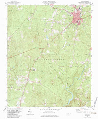 1982 Troy1983 Print · USGSTroy and the surrounding Uwharrie hills are captured here in the early eighties, showing a landscape shaped by the timber industry and the Little River. Genealogists can trace family names at Ropers Grove Cem, Liberty Ch, and the small settlement of Wadeville.
 - 1982 Map of Southern Pines, 1983 Print
 1982 Southern Pines1983 Print · USGSCentral North Carolina in the early eighties shows a landscape defined by military expansion and historic rail corridors. Researchers can trace the legacy of the Seaboard Coast Line through Pinehurst or locate landmarks like the Town Creek Indian Mound State Historic Site.
 - 1983 Map of Lovejoy
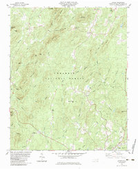 1983 Lovejoy1983 Print · USGSMontgomery County was still defined by its deep timber and quiet crossroads at the start of the 1980s. Researchers can trace rural life through sites like Macedonia Ch, the Zoar Cem, and the small settlement of Ophir near the Uwharrie River.
 - 1983 Map of Star
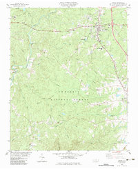
 1983 Star1983 Print · USGSMontgomery County in the early eighties shows a transition from forest and mining to a rail-centered community. Trace local family history and industry through landmarks like Black Ankle Mine, the Star Sch, and Forks of Little River Ch.
 - 1983 Map of Biscoe
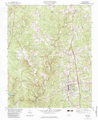
 1983 Biscoe1983 Print · USGSBiscoe and Candor are shown in the early eighties as they functioned as local hubs along the Norfolk Southern railroad. Genealogists can trace family roots through numerous rural landmarks like Parsons Grove Ch Cem, Montgomery Tech Institute, and Macedonia Ch.
End of results
Showing maps 1-5 of 5
Top cities near Troy
- Norwood historical maps
- Biscoe historical maps
- Mount Gilead historical maps
- Badin historical maps
- Candor historical maps
- Star historical maps
See more
Frequently asked questions
- What are the different types of historical maps available for Troy?
- What is the oldest map of Troy?
- Where can I purchase historical maps of Troy for my home or office?
- Where can I download high-res historical maps of Troy?
- Are there historical topographic maps available for Troy?
- Is there historical aerial imagery available for Troy?
- Where are historical maps of Troy sourced from?