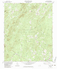
1983 Map of Lovejoy
USGS Topo · Published 1983About this map
Uwharrie National Forest dominates this section of Montgomery County, where the dense timber of the Uwharrie Mountains is broken only by small rural settlements and scattered family churches. In the early 1980s, these hills remained sparsely populated, with communities like Ophir, Abner, and Lovejoy serving as local anchors. The landscape is defined by its many summits, including Wysner Mountain and Jenny Wright Mtn, and a complex drainage system where Poison Fork and Dumas Creek carve through the narrow valleys. Genealogy researchers will find several well-placed landmarks, from the Lomax Memorial Ch Cem in the south to Zoar Cem near Bunnel Mtn. The southern edge of the sheet touches the outskirts of Troy, where the Norfolk Southern line skirts the town, providing a glimpse of the area's transition from the deep forest to a more established county hub.
Find a feature on this map
52 named features on this map. Tap any name to fly to it.
Don’t see what you’re looking for? This feature index may not catch every label — zoom into the map to look around manually.
Map Details
Editions of this 1983 Lovejoy Map
This is the sole edition of this map. No revisions or reprints were ever made.
Other maps of this area

1942 · Troy
USGS Topo · 1:125,000

1953 · Raleigh
USGS Topo · 1:250,000

1953 · Charlotte
USGS Topo · 1:250,000

1954 · Charlotte
USGS Topo · 1:250,000

1954 · Raleigh
USGS Topo · 1:250,000

1957 · Albemarle
USGS Topo · 1:62,500

1957 · Denton
USGS Topo · 1:62,500

1957 · Troy
USGS Topo · 1:62,500

1957 · Asheboro
USGS Topo · 1:62,500

1960 · Charlotte
USGS Topo · 1:250,000