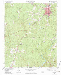
1982 Map of Troy
USGS Topo · Published 1983About this map
Troy serves as the Montgomery County seat, centered on a street grid that includes the Hosp, Po, and City Hall. The town’s industrial and civic infrastructure is evident in the Filtration Plant and Substation, while the Norfolk Southern railroad provides a vital transportation corridor through the rolling hills. To the southwest, the Uwharrie National Forest covers much of the landscape, punctuated by small rural settlements like Wadeville and Roberdo.
Find a feature on this map
54 named features on this map. Tap any name to fly to it.
Don’t see what you’re looking for? This feature index may not catch every label — zoom into the map to look around manually.
Map Details
Editions of this 1982 Troy Map
This is the sole edition of this map. No revisions or reprints were ever made.
Other maps of this area

1942 · Troy
USGS Topo · 1:125,000

1953 · Raleigh
USGS Topo · 1:250,000

1953 · Charlotte
USGS Topo · 1:250,000

1954 · Charlotte
USGS Topo · 1:250,000

1954 · Raleigh
USGS Topo · 1:250,000

1956 · Mount Gilead East
USGS Topo · 1:24,000

1956 · Harrisville
USGS Topo · 1:24,000

1956 · Mount Gilead West
USGS Topo · 1:24,000

1957 · Albemarle
USGS Topo · 1:62,500

1957 · Troy
USGS Topo · 1:62,500