1980s Maps of Murraysville, North Carolina
Explore 2 historic maps of Murraysville from the 1980s. These maps offer a rare glimpse into what life looked like during the 1980s — showing old roads, neighborhoods, homes, and landmarks that have changed or disappeared over time.
Whether you're researching your family's past, planning a metal detecting trip, or studying how Murraysville's landscape evolved across the 1980s, these high-resolution maps are a powerful tool for exploring the history of this region.
- Focus on a specific era: All maps on this page are from the 1980s, giving you a focused view of this time period.
- See what’s changed: Compare century-old streets, trails, and buildings to today's modern landscape using overlays and satellite layers.
- Research with precision: Use these maps for genealogy, historical research, land use analysis, or educational projects.
- View, download, or print: Maps are fully viewable online in high resolution, and can be downloaded or printed for your own records.
Start exploring Murraysville's history through authentic maps from the 1980s. This is your window into the past.
Murraysville, NC maps
(2)- 1980 Map of Scotts Hill, 1985 Print
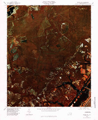 1980 Scotts Hill1985 Print · USGSCoastal New Hanover County is frozen in time during the early eighties, showing the region's transition from rural timberland to developing neighborhoods. Researchers can trace the winding paths of Pages Creek and Howe Creek or locate early layouts of Murraysville and Scotts Hill.
 - 1984 Map of Wilmington, 1985 Print
 1984 Wilmington1985 Print · USGSThe Lower Cape Fear region is shown here in the mid-1980s as the coastal corridor between Wilmington and the barrier islands experienced significant development. Researchers can trace historic river landings, the winding Intracoastal Waterway, and established communities from Castle Hayne to Topsail Beach.
End of results
Showing maps 1-2 of 2
Top cities near Murraysville
- Wilmington historical maps
- Leland historical maps
- Boiling Spring Lakes historical maps
- Wrightsville Beach historical maps
- Navassa historical maps
- Topsail Beach historical maps
See more
Frequently asked questions
- What are the different types of historical maps available for Murraysville?
- What is the oldest map of Murraysville?
- Where can I purchase historical maps of Murraysville for my home or office?
- Where can I download high-res historical maps of Murraysville?
- Are there historical topographic maps available for Murraysville?
- Is there historical aerial imagery available for Murraysville?
- Where are historical maps of Murraysville sourced from?