1920s Maps of Northampton County, North Carolina
Explore 3 historic maps of Northampton County from the 1920s. These maps offer a rare glimpse into what life looked like during the 1920s — showing old roads, neighborhoods, homes, and landmarks that have changed or disappeared over time.
Whether you're researching your family's past, planning a metal detecting trip, or studying how Northampton County's landscape evolved across the 1920s, these high-resolution maps are a powerful tool for exploring the history of this region.
- Focus on a specific era: All maps on this page are from the 1920s, giving you a focused view of this time period.
- See what’s changed: Compare century-old streets, trails, and buildings to today's modern landscape using overlays and satellite layers.
- Research with precision: Use these maps for genealogy, historical research, land use analysis, or educational projects.
- View, download, or print: Maps are fully viewable online in high resolution, and can be downloaded or printed for your own records.
Start exploring Northampton County's history through authentic maps from the 1920s. This is your window into the past.
Northampton County, NC maps
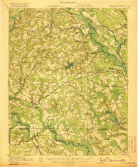
(3)- 1920 Map of White Plains
 1920 White Plains1920 Print · USGSThe Virginia and North Carolina borderlands come to life in this 1920 survey of the Meherrin and Roanoke river basins. Genealogists can trace family names at Drumgoole Store and Phipps Store, or locate old schoolhouse sites like Meherrin School and Webb School.4 unique versions available
 - 1920 Map of Boykins
 1920 Boykins1920 Print · USGSCoastal plain settlements near the Virginia and North Carolina line thrive along the river systems and railroads of the post-WWI era. Genealogists can trace family roots at Ebenezer Church, Johnsons School, and mills like Smiths Mill.2 unique versions available
 - 1920 Map of Arringdale
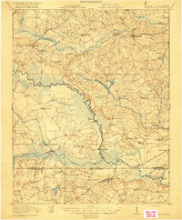 1920 Arringdale1920 Print · USGSCoastal plain life at the state line centered on the river and rail just after the Great War. Genealogists can locate family-named landmarks like Pearsons Millpond and several rural centers including Rising Star School, Hebron Church, and Arringdale.3 unique versions available
End of results
Showing maps 1-3 of 3
Top cities of Northampton County
- Garysburg historical maps
- Rich Square historical maps
- Gaston historical maps
- Woodland historical maps
- Conway historical maps
- Jackson historical maps
See more
Frequently asked questions
- What are the different types of historical maps available for Northampton County?
- What is the oldest map of Northampton County?
- Where can I purchase historical maps of Northampton County for my home or office?
- Where can I download high-res historical maps of Northampton County?
- Are there historical topographic maps available for Northampton County?
- Is there historical aerial imagery available for Northampton County?
- Where are historical maps of Northampton County sourced from?