2020s Maps of Elizabeth City, North Carolina
Explore 2 historic maps of Elizabeth City from the 2020s. These maps offer a rare glimpse into what life looked like during the 2020s — showing old roads, neighborhoods, homes, and landmarks that have changed or disappeared over time.
Whether you're researching your family's past, planning a metal detecting trip, or studying how Elizabeth City's landscape evolved across the 2020s, these high-resolution maps are a powerful tool for exploring the history of this region.
- Focus on a specific era: All maps on this page are from the 2020s, giving you a focused view of this time period.
- See what’s changed: Compare century-old streets, trails, and buildings to today's modern landscape using overlays and satellite layers.
- Research with precision: Use these maps for genealogy, historical research, land use analysis, or educational projects.
- View, download, or print: Maps are fully viewable online in high resolution, and can be downloaded or printed for your own records.
Start exploring Elizabeth City's history through authentic maps from the 2020s. This is your window into the past.
Elizabeth City, NC maps
(2)- 2022 Map of Elizabeth City, 2022 Print
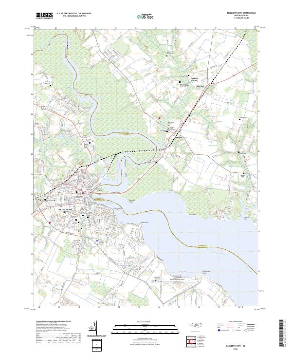 2022 Elizabeth City2022 Print · USGSElizabeth City and the surrounding coastal plain of the Albemarle region are shown here in the early twenty-first century. Genealogists and local historians can locate many family-named landmarks, including Boushall Cem, Enoch Sawyer Cem, and the Elizabeth City State University campus.
 - 2022 Map of Pasquotank, 2022 Print
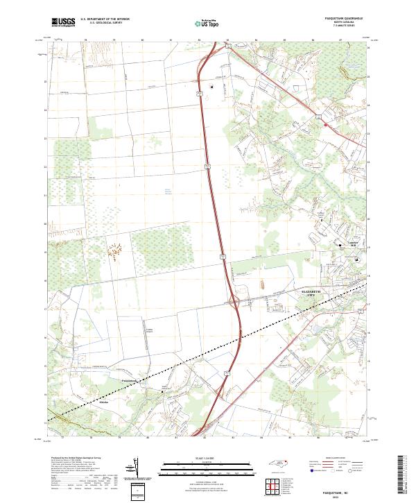 2022 Pasquotank2022 Print · USGSCoastal North Carolina comes to life in the early 2020s as the suburbs of Elizabeth City meet the wild Great Dismal Swamp. Genealogists can locate several family burial grounds, including the Pritchard Family Cem, and trace the industrial legacy of the Lumber Mill.
End of results
Showing maps 1-2 of 2
Top cities near Elizabeth City
Top neighborhoods of Elizabeth City
- Tanglewood historical maps
- Chapell Gardens historical maps
- Harbor Bay Townhomes historical maps
- Oxford Heights historical maps
- Brookridge Terrace historical maps
- Rosewood historical maps
See more
Frequently asked questions
- What are the different types of historical maps available for Elizabeth City?
- What is the oldest map of Elizabeth City?
- Where can I purchase historical maps of Elizabeth City for my home or office?
- Where can I download high-res historical maps of Elizabeth City?
- Are there historical topographic maps available for Elizabeth City?
- Is there historical aerial imagery available for Elizabeth City?
- Where are historical maps of Elizabeth City sourced from?