1980s Maps of Fountain, North Carolina
Explore 3 historic maps of Fountain from the 1980s. These maps offer a rare glimpse into what life looked like during the 1980s — showing old roads, neighborhoods, homes, and landmarks that have changed or disappeared over time.
Whether you're researching your family's past, planning a metal detecting trip, or studying how Fountain's landscape evolved across the 1980s, these high-resolution maps are a powerful tool for exploring the history of this region.
- Focus on a specific era: All maps on this page are from the 1980s, giving you a focused view of this time period.
- See what’s changed: Compare century-old streets, trails, and buildings to today's modern landscape using overlays and satellite layers.
- Research with precision: Use these maps for genealogy, historical research, land use analysis, or educational projects.
- View, download, or print: Maps are fully viewable online in high resolution, and can be downloaded or printed for your own records.
Start exploring Fountain's history through authentic maps from the 1980s. This is your window into the past.
Fountain, NC maps
(3)- 1980 Map of Falkland, 1981 Print
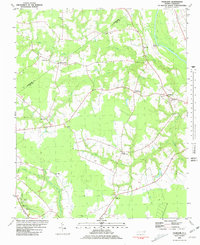 1980 Falkland1981 Print · USGSPitt County's rural landscape is captured here in the late seventies, centered on the river-bend settlement of Falkland. Researchers can trace old family sites and community centers like Sharp Point, Dupree Landing, and Kings Crossroads.2 unique versions available
 - 1981 Map of Fountain, 1982 Print
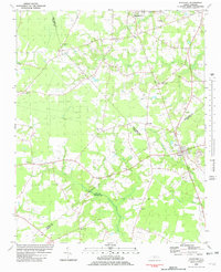 1981 Fountain1982 Print · USGSCoastal plain agriculture and small-town life in the early eighties center on the rural crossroads of Pitt and Edgecombe counties. Trace the roots of local communities at Piney Grove Sch, an Old Railroad Grade, and Webbtown Ch.
 - 1985 Map of Rocky Mount
 1985 Rocky Mount1985 Print · USGSThe eastern North Carolina coastal plain in the mid-eighties shows a landscape defined by its river-and-rail heritage. Genealogists and local historians can trace the development of Rocky Mount, Greenville, and Wilson, or locate landmarks like East Carolina University and the Voice of America site.2 unique versions available
End of results
Showing maps 1-3 of 3
Top cities near Fountain
- Greenville historical maps
- Tarboro historical maps
- Ayden historical maps
- Winterville historical maps
- Farmville historical maps
- Sharpsburg historical maps
See more
Top neighborhoods of Fountain
Frequently asked questions
- What are the different types of historical maps available for Fountain?
- What is the oldest map of Fountain?
- Where can I purchase historical maps of Fountain for my home or office?
- Where can I download high-res historical maps of Fountain?
- Are there historical topographic maps available for Fountain?
- Is there historical aerial imagery available for Fountain?
- Where are historical maps of Fountain sourced from?