1990s Maps of Randolph County, North Carolina
Explore 8 historic maps of Randolph County from the 1990s. These maps offer a rare glimpse into what life looked like during the 1990s — showing old roads, neighborhoods, homes, and landmarks that have changed or disappeared over time.
Whether you're researching your family's past, planning a metal detecting trip, or studying how Randolph County's landscape evolved across the 1990s, these high-resolution maps are a powerful tool for exploring the history of this region.
- Focus on a specific era: All maps on this page are from the 1990s, giving you a focused view of this time period.
- See what’s changed: Compare century-old streets, trails, and buildings to today's modern landscape using overlays and satellite layers.
- Research with precision: Use these maps for genealogy, historical research, land use analysis, or educational projects.
- View, download, or print: Maps are fully viewable online in high resolution, and can be downloaded or printed for your own records.
Start exploring Randolph County's history through authentic maps from the 1990s. This is your window into the past.
Randolph County, NC maps
(8)- 1993 Map of High Point West, 1999 Print
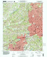 1993 High Point West1999 Print · USGSThe industrial corridor between Davidson and Guilford counties is shown here during the late twentieth century. Genealogists and local historians can trace the growth of High Point and Thomasville, locating landmarks from Westchester Academy to Hedgecock Chapel.
 - 1993 Map of High Point East, 1999 Print
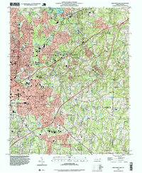 1993 High Point East1999 Print · USGSCentral North Carolina settlement and development are charted here as the suburbs of HIGH POINT reach into the surrounding countryside. Genealogists can trace family footprints through sites like Green Hill Cem, McCain Sch, and churches such as Friendly Ch.
 - 1994 Map of Eleazer, 1996 Print
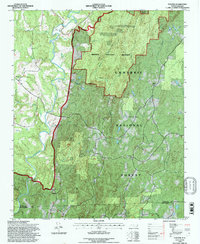 1994 Eleazer1996 Print · USGSThe Randolph and Montgomery county line comes alive in the mid-1990s, showcasing the protected woodlands of the Uwharrie National Forest. Genealogists and historians can locate community landmarks like Oak Grove Ch and Mt Lebanon Ch near the settlements of Eleazer and Abner.
 - 1994 Map of Handy, 1996 Print
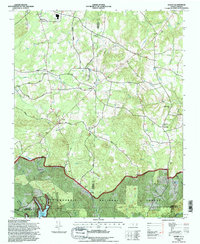 1994 Handy1996 Print · USGSDavidson County in the mid-1990s showcases a landscape where the Uwharrie National Forest meets rural crossroads settlements. Researchers can trace local lineage through sites like Salem Ch Cem and community landmarks such as Handy and Siloam Ch.
 - 1994 Map of Asheboro, 1996 Print
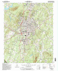 1994 Asheboro1996 Print · USGSAsheboro expanded across the Randolph County Piedmont in the mid-nineties, balancing urban growth with its surrounding wild lands. Researchers can trace the development of North Asheboro and locate family landmarks like Whispering Pines Ch and Balfour Sch.
 - 1994 Map of Farmer, 1996 Print
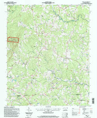
 1994 Farmer1996 Print · USGSRandolph County's rural heartland is captured here in the mid-1990s, where the Uwharrie Mountains meet winding river valleys. Researchers can locate community centers like Farmer and trace family-named landmarks including Hoovers Grove Ch and Sawyersville.
 - 1994 Map of Seagrove, 1996 Print
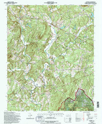
 1994 Seagrove1996 Print · USGSThe community of Seagrove and the surrounding North Carolina Piedmont are captured here in the mid-nineties during a period of steady rural continuity. Researchers can locate many local landmarks, including Pisgah Ch, the unique settlement of Whynot, and the rugged boundaries of the Uwharrie National Forest.
 - 1994 Map of Erect, 1998 Print
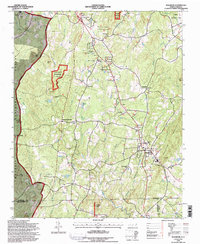
 1994 Erect1998 Print · USGSThe North Carolina Piedmont is documented here in the mid-1990s, where the Randolph Co and Moore Co border meets. Genealogists can trace rural life through numerous sites like Needhams Grove Church, Yow Mill, and Erect.
End of results
Showing maps 1-8 of 8
Top cities of Randolph County
- Asheboro historical maps
- Archdale historical maps
- Trinity historical maps
- Randleman historical maps
- Liberty historical maps
- Ramseur historical maps
See more
Frequently asked questions
- What are the different types of historical maps available for Randolph County?
- What is the oldest map of Randolph County?
- Where can I purchase historical maps of Randolph County for my home or office?
- Where can I download high-res historical maps of Randolph County?
- Are there historical topographic maps available for Randolph County?
- Is there historical aerial imagery available for Randolph County?
- Where are historical maps of Randolph County sourced from?