1970s Maps of Rowan County, North Carolina
Explore 8 historic maps of Rowan County from the 1970s. These maps offer a rare glimpse into what life looked like during the 1970s — showing old roads, neighborhoods, homes, and landmarks that have changed or disappeared over time.
Whether you're researching your family's past, planning a metal detecting trip, or studying how Rowan County's landscape evolved across the 1970s, these high-resolution maps are a powerful tool for exploring the history of this region.
- Focus on a specific era: All maps on this page are from the 1970s, giving you a focused view of this time period.
- See what’s changed: Compare century-old streets, trails, and buildings to today's modern landscape using overlays and satellite layers.
- Research with precision: Use these maps for genealogy, historical research, land use analysis, or educational projects.
- View, download, or print: Maps are fully viewable online in high resolution, and can be downloaded or printed for your own records.
Start exploring Rowan County's history through authentic maps from the 1970s. This is your window into the past.
Rowan County, NC maps
(8)- 1970 Map of Enochville, 1972 Print
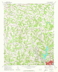 1970 Enochville1972 Print · USGSRowan and Cabarrus counties in the early seventies reveal a landscape of rural congregations and emerging utility networks. Researchers can trace family history through numerous landmarks like St Pauls Ch, McKnight Sch, and the community at Enochville.
 - 1970 Map of China Grove, 1972 Print
 1970 China Grove1972 Print · USGSRowan and Cabarrus counties are captured here during a period of significant growth along the Southern railway corridor. Genealogists and local historians can trace the evolution of China Grove and Landis, or locate landmarks like Bostian Sch and Millers Chapel.2 unique versions available
 - 1970 Map of Cleveland, 1972 Print
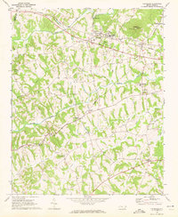 1970 Cleveland1972 Print · USGSRowan County in the early seventies centers on the rail-side community of Cleveland and the rural crossroads of Mount Ulla. Genealogists and historians can trace the foundations of the community through Thyatira Ch, Mill Bridge, and Knox Chapel.2 unique versions available
 - 1977 Map of High Rock, 1979 Print
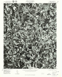
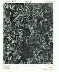
 1977 High Rock1979 Print · USGSCentral North Carolina in the late seventies is captured here through aerial photography, showing the rural riverfront before modern suburban expansion. Researchers can trace land ownership patterns and rural crossroads near Healing Springs, Jackson Hill, and along the banks of the Yadkin River.
 - 1977 Map of Rockwell, 1979 Print
 1977 Rockwell1979 Print · USGSRowan County in the late seventies is shown in remarkable aerial detail, from the granite-rich hills to the winding creek bottoms. Researchers can trace the layout of Rockwell, Granite Quarry, and the rural community near Shuping Mill.
 - 1977 Map of Gold Hill, 1979 Print
 1977 Gold Hill1979 Print · USGSGold Hill and the rural stretches of Rowan County appear in detail in the late seventies. Researchers can trace the sprawling shoreline of High Rock Lake and locate specific rural homesteads near Liberty and the historic Gold Hill mining district.
 - 1977 Map of Churchland, 1979 Print
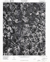 1977 Churchland1979 Print · USGSThe Yadkin River valley in the late seventies is captured here in sharp photographic detail, showing the rural landscape around the Horseshoe bend. Researchers can trace land use and homesteads near the old communities of Churchland, Petersville, and Tyro.
 - 1977 Map of Salisbury, 1980 Print
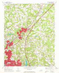
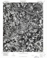 1977 Salisbury1980 Print · USGSSalisbury and its surrounding Rowan County communities are captured in this mid-seventies aerial survey as the region's suburban footprint began to expand. Genealogists and local historians can trace specific properties and landmarks near Ellis Crossroads, Franklin, and the banks of the Yadkin River.
End of results
Showing maps 1-8 of 8
Top cities of Rowan County
- Salisbury historical maps
- China Grove historical maps
- Spencer historical maps
- Landis historical maps
- Granite Quarry historical maps
- Rockwell historical maps
See more
Frequently asked questions
- What are the different types of historical maps available for Rowan County?
- What is the oldest map of Rowan County?
- Where can I purchase historical maps of Rowan County for my home or office?
- Where can I download high-res historical maps of Rowan County?
- Are there historical topographic maps available for Rowan County?
- Is there historical aerial imagery available for Rowan County?
- Where are historical maps of Rowan County sourced from?