1990s Maps of Rowan County, North Carolina
Explore 4 historic maps of Rowan County from the 1990s. These maps offer a rare glimpse into what life looked like during the 1990s — showing old roads, neighborhoods, homes, and landmarks that have changed or disappeared over time.
Whether you're researching your family's past, planning a metal detecting trip, or studying how Rowan County's landscape evolved across the 1990s, these high-resolution maps are a powerful tool for exploring the history of this region.
- Focus on a specific era: All maps on this page are from the 1990s, giving you a focused view of this time period.
- See what’s changed: Compare century-old streets, trails, and buildings to today's modern landscape using overlays and satellite layers.
- Research with precision: Use these maps for genealogy, historical research, land use analysis, or educational projects.
- View, download, or print: Maps are fully viewable online in high resolution, and can be downloaded or printed for your own records.
Start exploring Rowan County's history through authentic maps from the 1990s. This is your window into the past.
Rowan County, NC maps
(4)- 1993 Map of Mooresville, 1996 Print
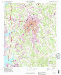 1993 Mooresville1996 Print · USGSMooresville and the shoreline of Lake Norman are captured in the mid-nineties as the region balanced its textile-town roots with lakeside growth. Researchers can locate family landmarks like Willow Valley Cem, the Dunbar Sch, and Davidson College.
 - 1993 Map of Enochville, 1996 Print
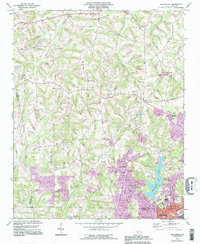 1993 Enochville1996 Print · USGSThe rural borders of Rowan and Cabarrus counties are captured here in the 1990s as longstanding communities began to expand. Genealogists can locate family landmarks such as McKnight Sch and Pleasant Grove Ch alongside Kannapolis Lake.
 - 1994 Map of High Rock, 1996 Print
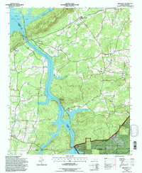 1994 High Rock1996 Print · USGSThe Yadkin River valley in the mid-nineties shows a landscape defined by major reservoirs and the Winston-Salem Southbound rail line. Genealogists can locate family landmarks like Healing Springs, Poletown, and rural congregations at Lick Creek Ch or Taylor Grove Ch.
 - 1997 Map of Cool Springs, 2000 Print
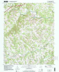 1997 Cool Springs2000 Print · USGSRowan and Iredell counties are captured here in the late nineties, documenting a landscape defined by rolling Piedmont terrain and deep-rooted creek-side settlements. Genealogists can locate family landmarks like Moores Chapel, Providence Cem, and the crossroads at Needmore.
End of results
Showing maps 1-4 of 4
Top cities of Rowan County
- Salisbury historical maps
- China Grove historical maps
- Spencer historical maps
- Landis historical maps
- Granite Quarry historical maps
- Rockwell historical maps
See more
Frequently asked questions
- What are the different types of historical maps available for Rowan County?
- What is the oldest map of Rowan County?
- Where can I purchase historical maps of Rowan County for my home or office?
- Where can I download high-res historical maps of Rowan County?
- Are there historical topographic maps available for Rowan County?
- Is there historical aerial imagery available for Rowan County?
- Where are historical maps of Rowan County sourced from?