1990s Maps of Stanly County, North Carolina
Explore 8 historic maps of Stanly County from the 1990s. These maps offer a rare glimpse into what life looked like during the 1990s — showing old roads, neighborhoods, homes, and landmarks that have changed or disappeared over time.
Whether you're researching your family's past, planning a metal detecting trip, or studying how Stanly County's landscape evolved across the 1990s, these high-resolution maps are a powerful tool for exploring the history of this region.
- Focus on a specific era: All maps on this page are from the 1990s, giving you a focused view of this time period.
- See what’s changed: Compare century-old streets, trails, and buildings to today's modern landscape using overlays and satellite layers.
- Research with precision: Use these maps for genealogy, historical research, land use analysis, or educational projects.
- View, download, or print: Maps are fully viewable online in high resolution, and can be downloaded or printed for your own records.
Start exploring Stanly County's history through authentic maps from the 1990s. This is your window into the past.
Stanly County, NC maps
(8)- 1993 Map of Richfield, 1996 Print
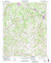 1993 Richfield1996 Print · USGSStanly County was characterized by its distributed Piedmont settlements and institutional centers like Pfeiffer College during the 1990s. Researchers can trace family-named locations and rural landmarks such as Millingport, Bethlehem Ch, and Bear Creek Airport.
 - 1993 Map of Midland, 1996 Print
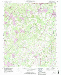 1993 Midland1996 Print · USGSMidland and Mint Hill are shown here in the early nineties, a period where family-run farms and country churches still defined the borderlands of Cabarrus and Mecklenburg. Trace local history through landmarks like Union Cem, Mill Grove Ch, and the Bethel Sch.
 - 1993 Map of New London, 1996 Print
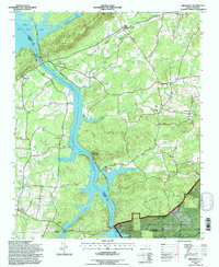
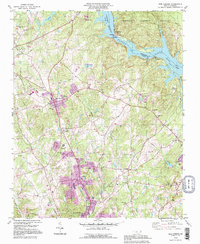 1993 New London1996 Print · USGSStanly County’s industrial and rural landscape is captured here during a time of notable growth and infrastructure development. Genealogists and historians can trace local landmarks like the Island Graveyard, Parker Memorial Ch Cem, and the old settlement at Palestine.
 - 1993 Map of Albemarle, 1996 Print
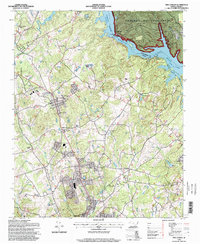
 1993 Albemarle1996 Print · USGSThe city of Albemarle expanded throughout the late twentieth century as shown in this detailed survey of its residential and industrial growth. Genealogists can trace family sites at Fairview Mem Park and Old Freedom Cem.
 - 1994 Map of Morrow Mountain, 1996 Print
 1994 Morrow Mountain1996 Print · USGSThe Montgomery and Stanly county borderlands appear in the mid-nineties as a blend of recreational forest and lakeside residential growth. Researchers can trace the development of Sugarloaf Shores or locate rural landmarks like Randall Ch and the White Clay Quarry.
 - 1994 Map of Badin, 1996 Print
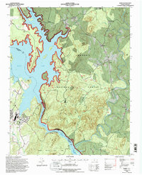 1994 Badin1996 Print · USGSThe Uwharrie Mountains and the sprawling waters of Badin Lake define this North Carolina landscape in the mid-nineties. Researchers can locate family landmarks like Russell Cem, the Coggins Mine, and the historic Badin Sch.2 unique versions available
 - 1994 Map of High Rock, 1996 Print
 1994 High Rock1996 Print · USGSThe Yadkin River valley in the mid-nineties shows a landscape defined by major reservoirs and the Winston-Salem Southbound rail line. Genealogists can locate family landmarks like Healing Springs, Poletown, and rural congregations at Lick Creek Ch or Taylor Grove Ch.
 - 1994 Map of New London, 1998 Print
 1994 New London1998 Print · USGSStanly County at the close of the twentieth century shows a landscape shaped by the Yadkin River and a network of rural communities. Researchers can locate family landmarks such as Parkers Grove Ch, trace the Winston-Salem Southbound rail line, or explore the developed shores of Badin Lake.
End of results
Showing maps 1-8 of 8
Top cities of Stanly County
- Albemarle historical maps
- Norwood historical maps
- Stanfield historical maps
- Badin historical maps
- Oakboro historical maps
- Red Cross historical maps
See more
Frequently asked questions
- What are the different types of historical maps available for Stanly County?
- What is the oldest map of Stanly County?
- Where can I purchase historical maps of Stanly County for my home or office?
- Where can I download high-res historical maps of Stanly County?
- Are there historical topographic maps available for Stanly County?
- Is there historical aerial imagery available for Stanly County?
- Where are historical maps of Stanly County sourced from?