1990s Maps of Stokes County, North Carolina
Explore 6 historic maps of Stokes County from the 1990s. These maps offer a rare glimpse into what life looked like during the 1990s — showing old roads, neighborhoods, homes, and landmarks that have changed or disappeared over time.
Whether you're researching your family's past, planning a metal detecting trip, or studying how Stokes County's landscape evolved across the 1990s, these high-resolution maps are a powerful tool for exploring the history of this region.
- Focus on a specific era: All maps on this page are from the 1990s, giving you a focused view of this time period.
- See what’s changed: Compare century-old streets, trails, and buildings to today's modern landscape using overlays and satellite layers.
- Research with precision: Use these maps for genealogy, historical research, land use analysis, or educational projects.
- View, download, or print: Maps are fully viewable online in high resolution, and can be downloaded or printed for your own records.
Start exploring Stokes County's history through authentic maps from the 1990s. This is your window into the past.
Stokes County, NC maps
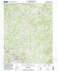
(6)- 1996 Map of Walnut Cove, 2001 Print
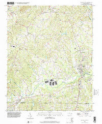 1996 Walnut Cove2001 Print · USGSStokes County communities are captured here in the mid-1990s as they developed along the regional waterways. Researchers can locate specific family landmarks and local institutions like Germanton, the South Stokes High Sch, and Fulp Memorial Ch.
 - 1996 Map of Ayersville, 2001 Print
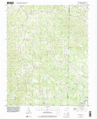 1996 Ayersville2001 Print · USGSStokes and Rockingham Counties are shown in the mid-1990s as a landscape of rural crossroads and river-valley settlements. Researchers can trace family history through local landmarks like Mt Hermon Ch, Prestonville, and the small community of Dodgetown.
 - 1996 Map of King, 2001 Print
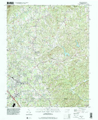 1996 King2001 Print · USGSThe borderlands of Forsyth and Stokes County come alive in the late nineties, from the growing streets of King to the peaks of Sauratown Mtn. Genealogists and historians can trace family burial sites like Sizemore Cem and Old Mt Olive Cem near old crossroads like Capella.
 - 1996 Map of Danbury, 2001 Print
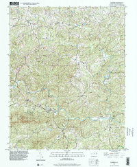 1996 Danbury2001 Print · USGSThe Dan River valley and the eastern edge of the Sauratown Mountains come into focus in the mid-1990s. Genealogists can trace family footprints around Danbury, Lawsonville, and local landmarks like Spencer Hill Memorial Ch and Davis Chapel.
 - 1997 Map of Hanging Rock, 1999 Print
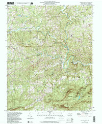 1997 Hanging Rock1999 Print · USGSStokes County in the late 1990s reveals a landscape of high ridges and rural homesteads centered around the Dan River. Researchers can locate several family cemeteries and country schools such as Brown Mtn Sch and Kings Mtn View Ch.
 - 1997 Map of Pilot Mountain, 2000 Print
 1997 Pilot Mountain2000 Print · USGSSurry and Stokes counties meet in this late-century topographic study of the North Carolina Piedmont. Researchers can trace numerous family burial sites like Locust Grove Cemetery and Jessup Grove Cemetery, alongside landmarks like Westfield and the Fish Hatchery.
End of results
Showing maps 1-6 of 6
Top cities of Stokes County
Frequently asked questions
- What are the different types of historical maps available for Stokes County?
- What is the oldest map of Stokes County?
- Where can I purchase historical maps of Stokes County for my home or office?
- Where can I download high-res historical maps of Stokes County?
- Are there historical topographic maps available for Stokes County?
- Is there historical aerial imagery available for Stokes County?
- Where are historical maps of Stokes County sourced from?