1970s Maps of Surry County, North Carolina
Explore 15 historic maps of Surry County from the 1970s. These maps offer a rare glimpse into what life looked like during the 1970s — showing old roads, neighborhoods, homes, and landmarks that have changed or disappeared over time.
Whether you're researching your family's past, planning a metal detecting trip, or studying how Surry County's landscape evolved across the 1970s, these high-resolution maps are a powerful tool for exploring the history of this region.
- Focus on a specific era: All maps on this page are from the 1970s, giving you a focused view of this time period.
- See what’s changed: Compare century-old streets, trails, and buildings to today's modern landscape using overlays and satellite layers.
- Research with precision: Use these maps for genealogy, historical research, land use analysis, or educational projects.
- View, download, or print: Maps are fully viewable online in high resolution, and can be downloaded or printed for your own records.
Start exploring Surry County's history through authentic maps from the 1970s. This is your window into the past.
Surry County, NC maps
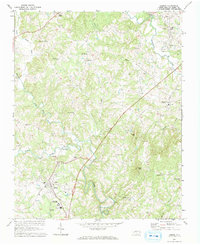
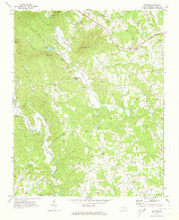
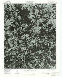
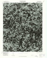
(15)- 1970 Map of Siloam, 1973 Print
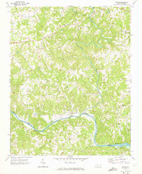 1970 Siloam1973 Print · USGSSurry County and Yadkin County are shown here in the early seventies, centered on the river-bend communities and the busy rail corridor. Researchers can trace rural lineages through the many cemeteries and country churches like Pine Hill Ch and Stanford Ch near the banks of the Ararat River.
 - 1970 Map of Copeland, 1973 Print
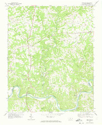 1970 Copeland1973 Print · USGSSurry County and the northern banks of the Yadkin River are captured here during the early 1970s. Local researchers can trace the rail-and-river geography of settlements like Rockford and Crutchfield or locate country landmarks such as Bear Creek Ch and Level Cross.2 unique versions available
 - 1970 Map of Mount Airy South, 1973 Print
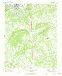
 1970 Mount Airy South1973 Print · USGSThe area south of Mount Airy comes alive in this 1970s survey, showing the expansion of settlements like Bannertown and Toast along the Ararat River. Genealogists and historians can trace numerous country landmarks, including Black Water Cem, Ash Hill, and Whitakers Chapel.2 unique versions available
 - 1971 Map of Thurmond, 1973 Print
 1971 Thurmond1973 Print · USGSWilkes and Surry counties meet along these wooded ridges during the early seventies, showing a landscape of tightly-knit rural communities. Genealogists and historians can trace family locations near Mining Ridge, Carter Falls, and numerous country churches like Roaring Gap Ch.
 - 1971 Map of Dobson, 1973 Print
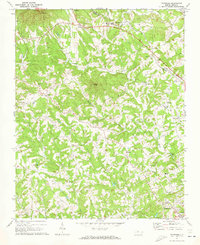
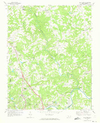
 1971 Dobson1973 Print · USGSThe county seat of Dobson is captured in the early seventies alongside emerging institutions and rural crossroads. Genealogists can trace family landmarks like Emmanuel Ch, Franklin Sch, and the riverside settlement of New Hope.3 unique versions available
 - 1971 Map of Elkin South, 1973 Print
 1971 Elkin South1973 Print · USGSCrossing the Yadkin River in the early 1970s, this area captures the industrial activity of Jonesville and the rural reaches of the Brushy Mountains. Genealogists and local historians can trace rural communities around Longtown, Fall Creek Ch, and Starmount High Sch.
 - 1971 Map of Elkin North, 1973 Print
 1971 Elkin North1973 Print · USGSSurry County communities north of the Yadkin River are captured here in the early 1970s as rural crossroads began to integrate with modern infrastructure. Researchers can trace historic local congregations at Union Cross Ch and Bessies Chapel, or locate family sites near Little Richmond and Zephyr.2 unique versions available
 - 1971 Map of Roaring Gap, 1973 Print
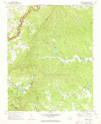 1971 Roaring Gap1973 Print · USGSThe North Carolina high country comes alive in the early 1970s as the Blue Ridge Parkway snakes through these Appalachian ridges. Researchers can trace family history at Thompson Cem or locate mountain landmarks like the Fish Hatchery and Roaring Gap Lookout Tower.2 unique versions available
 - 1971 Map of Bottom, 1973 Print
 1971 Bottom1973 Print · USGSSurry County in the early seventies was a land of steep knobs and river valleys where community life revolved around local landmarks. Trace family history at Salem Fork Cem, locate Blevins Store, or find the old Beulah Sch.3 unique versions available
 - 1976 Map of Cana, 1979 Print
 1976 Cana1979 Print · USGSThe Virginia-North Carolina border country comes into view in this mid-1970s aerial study of Carroll County and its neighbors. Genealogists and local historians can trace the exact field lines and road networks surrounding Cana, Toast, and Pine Ridge.
 - 1976 Map of Mount Airy North, 1979 Print
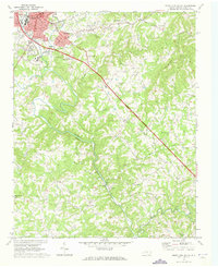
 1976 Mount Airy North1979 Print · USGSThe foothills of Surry County appear in photographic detail during the 1970s, centered on the northern edge of the Blue Ridge gateway. Trace the residential growth near Mount Airy and Toast or locate family home sites in Ararat and Flat Rock.
 - 1976 Map of Mount Airy South, 1979 Print
 1976 Mount Airy South1979 Print · USGSSurry County communities south of the Virginia border appear in high-altitude detail during the mid-seventies. Researchers can trace the development of residential clusters like Bannertown and Toast along the winding course of the Ararat River.
 - 1976 Map of Elkin South, 1979 Print
 1976 Elkin South1979 Print · USGSYadkin County and the river valley are captured in the mid-1970s, showing the precise layout of farms and settlements. Genealogists can trace the rural landscape surrounding Elkin, Wagoner, and the family-named landmarks of Arnold Mountain.
 - 1976 Map of Elkin North, 1979 Print
 1976 Elkin North1979 Print · USGSThe foothills of Surry County are captured in the mid-seventies, showing a patchwork of small farms and developing interstate corridors. Genealogists and local historians can trace the rural layouts of Zephyr, State Road, and the northern reaches of Elkin.
 - 1976 Map of Dobson, 1979 Print
 1976 Dobson1979 Print · USGSSurry County at the Bicentennial is captured in this aerial-based survey, showing the rural landscape around the town of Dobson. Local historians can trace exact land use and homestead locations near White Plains, Toast, and Turkey Ford.
End of results
Showing maps 1-15 of 15
Top cities of Surry County
Frequently asked questions
- What are the different types of historical maps available for Surry County?
- What is the oldest map of Surry County?
- Where can I purchase historical maps of Surry County for my home or office?
- Where can I download high-res historical maps of Surry County?
- Are there historical topographic maps available for Surry County?
- Is there historical aerial imagery available for Surry County?
- Where are historical maps of Surry County sourced from?