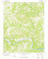
1970 Map of Siloam
USGS Topo · Published 1973About this map
The Ararat River winds through a landscape defined by small rural communities and the prominent Southern railroad line as it follows the Yadkin River valley. In the early 1970s, this area of the North Carolina foothills remained centered on small hubs like Siloam and Shoals, where the local Shoals Sch and a network of country churches provided the social foundations for residents. Numerous family-named landmarks and geographic features such as Bowman Mtn and Plowed Knob punctuate the terrain north of the Surry Co Yadkin Co boundary. The southeastern corner of the quadrangle touches the edge of Pilot Mtn State Park, reflecting the preservation of the region's distinctive topography. Along the river banks and creeks like Hogan Creek, small clusters of homes and cemeteries indicate a long-established pattern of settlement tied to the fertile bottomlands and the rail corridor.
Find a feature on this map
35 named features on this map. Tap any name to fly to it.
Don’t see what you’re looking for? This feature index may not catch every label — zoom into the map to look around manually.
Map Details
Editions of this 1970 Siloam Map
This is the sole edition of this map. No revisions or reprints were ever made.
Other maps of this area

1891 · Yadkinville
USGS Topo · 1:125,000

1893 · Yadkinville
USGS Topo · 1:125,000

1953 · Winston-Salem
USGS Topo · 1:250,000

1955 · Winston-Salem
USGS Topo · 1:250,000

1962 · Winston-Salem
USGS Topo · 1:250,000

1964 · Pinnacle
USGS Topo · 1:24,000

1964 · Pilot Mountain
USGS Topo · 1:24,000

1966 · Yadkinville
USGS Topo · 1:24,000

1966 · East Bend
USGS Topo · 1:24,000
1968 · Vienna
USGS Topo · 1:24,000