1990s Maps of Indian Trail, North Carolina
Explore 2 historic maps of Indian Trail from the 1990s. These maps offer a rare glimpse into what life looked like during the 1990s — showing old roads, neighborhoods, homes, and landmarks that have changed or disappeared over time.
Whether you're researching your family's past, planning a metal detecting trip, or studying how Indian Trail's landscape evolved across the 1990s, these high-resolution maps are a powerful tool for exploring the history of this region.
- Focus on a specific era: All maps on this page are from the 1990s, giving you a focused view of this time period.
- See what’s changed: Compare century-old streets, trails, and buildings to today's modern landscape using overlays and satellite layers.
- Research with precision: Use these maps for genealogy, historical research, land use analysis, or educational projects.
- View, download, or print: Maps are fully viewable online in high resolution, and can be downloaded or printed for your own records.
Start exploring Indian Trail's history through authentic maps from the 1990s. This is your window into the past.
Indian Trail, NC maps
(2)- 1993 Map of Midland, 1996 Print
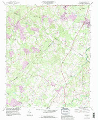 1993 Midland1996 Print · USGSMidland and Mint Hill are shown here in the early nineties, a period where family-run farms and country churches still defined the borderlands of Cabarrus and Mecklenburg. Trace local history through landmarks like Union Cem, Mill Grove Ch, and the Bethel Sch.
 - 1993 Map of Mint Hill, 1996 Print
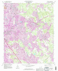 1993 Mint Hill1996 Print · USGSEastern Mecklenburg County is shown during a period of intense growth in the early nineties as residential neighborhoods pushed outward from the city. Researchers can locate long-standing community pillars like Philadelphia Ch and the Wilgrove Air Park alongside suburban expansions in Idlewild.
End of results
Showing maps 1-2 of 2
Top cities near Indian Trail
- Charlotte historical maps
- Monroe historical maps
- Matthews historical maps
- Indian Land historical maps
- Mint Hill historical maps
- Pineville historical maps
See more
Top neighborhoods of Indian Trail
Frequently asked questions
- What are the different types of historical maps available for Indian Trail?
- What is the oldest map of Indian Trail?
- Where can I purchase historical maps of Indian Trail for my home or office?
- Where can I download high-res historical maps of Indian Trail?
- Are there historical topographic maps available for Indian Trail?
- Is there historical aerial imagery available for Indian Trail?
- Where are historical maps of Indian Trail sourced from?