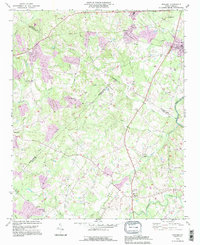
1993 Map of Midland
USGS Topo · Published 1996About this map
The Rocky River corridor forms a natural boundary on this 1990s landscape, where the rural character of eastern Mecklenburg and western Cabarrus counties is defined by a dense network of country churches and small crossroads. The community of Midland sits near the eastern edge, supported by landmarks like Mill Grove Ch and Macedonia Ch. To the west, the growing footprint of Mint Hill and Arlington transitions into a terrain carved by numerous tributaries, including Goose Creek, Clear Creek, and Muddy Creek.
Find a feature on this map
44 named features on this map. Tap any name to fly to it.
Don’t see what you’re looking for? This feature index may not catch every label — zoom into the map to look around manually.
Map Details
Editions of this 1993 Midland Map
This is the sole edition of this map. No revisions or reprints were ever made.
Other maps of this area

1941 · Charlotte
USGS Topo · 1:125,000

1942 · Charlotte
USGS Topo · 1:125,000

1949 · Harrisburg
USGS Topo · 1:24,000

1949 · Wilgrove
USGS Topo · 1:24,000

1949 · Midland
USGS Topo · 1:24,000

1949 · Concord SE
USGS Topo · 1:24,000

1953 · Charlotte
USGS Topo · 1:250,000

1954 · Charlotte
USGS Topo · 1:250,000

1957 · Mount Pleasant
USGS Topo · 1:62,500

1960 · Charlotte
USGS Topo · 1:250,000