1960s Maps of Knightdale, North Carolina
Explore 2 historic maps of Knightdale from the 1960s. These maps offer a rare glimpse into what life looked like during the 1960s — showing old roads, neighborhoods, homes, and landmarks that have changed or disappeared over time.
Whether you're researching your family's past, planning a metal detecting trip, or studying how Knightdale's landscape evolved across the 1960s, these high-resolution maps are a powerful tool for exploring the history of this region.
- Focus on a specific era: All maps on this page are from the 1960s, giving you a focused view of this time period.
- See what’s changed: Compare century-old streets, trails, and buildings to today's modern landscape using overlays and satellite layers.
- Research with precision: Use these maps for genealogy, historical research, land use analysis, or educational projects.
- View, download, or print: Maps are fully viewable online in high resolution, and can be downloaded or printed for your own records.
Start exploring Knightdale's history through authentic maps from the 1960s. This is your window into the past.
Knightdale, NC maps
(2)- 1967 Map of Knightdale, 1972 Print
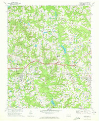 1967 Knightdale1972 Print · USGSEastern Wake County comes into focus in the mid-1960s, showing the rural character and emerging infrastructure between the capital and the coastal plain. Genealogists and local historians can trace family locations near Lizard Lick, Eagle Rock, and Hephzibah Ch.4 unique versions available
 - 1968 Map of Raleigh East, 1972 Print
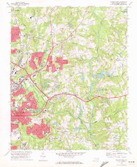 1968 Raleigh East1972 Print · USGSThe eastern expansion of Raleigh in the late sixties reveals a city emerging into the countryside near Milburnie and New Hope. Genealogists and historians can trace institutional sites like St Augustines College or local landmarks like Millbrook High Sch and Pet Crossroads.4 unique versions available
End of results
Showing maps 1-2 of 2
Top cities near Knightdale
- Raleigh historical maps
- Wake Forest historical maps
- Fuquay-Varina historical maps
- Clayton historical maps
- Garner historical maps
- Wendell historical maps
See more
Top neighborhoods of Knightdale
- Ashebrook at Planters Walk historical maps
- Matthews Glen at Planters Walk historical maps
- Mingo Creek historical maps
- Oaks at Planters Walk historical maps
- Churchill historical maps
- Poplar Creek Village historical maps
See more
Frequently asked questions
- What are the different types of historical maps available for Knightdale?
- What is the oldest map of Knightdale?
- Where can I purchase historical maps of Knightdale for my home or office?
- Where can I download high-res historical maps of Knightdale?
- Are there historical topographic maps available for Knightdale?
- Is there historical aerial imagery available for Knightdale?
- Where are historical maps of Knightdale sourced from?