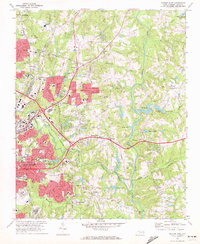
1968 Map of Raleigh East
USGS Topo · Published 1972About this map
The eastern edges of Raleigh undergo a visible transformation into suburban corridors in this late-1960s survey, where residential developments like Brentwood and Longview Gardens bridge the gap between the urban center and rural outposts. The Seaboard Coast Line Railroad and Norfolk Southern lines define the industrial and transit backbone of the area, cutting through a landscape increasingly marked by institutional growth. Major landmarks include St Augustines College, Wake Memorial Hosp, and the State Correctional Center.
Find a feature on this map
66 named features on this map. Tap any name to fly to it.
Don’t see what you’re looking for? This feature index may not catch every label — zoom into the map to look around manually.
Map Details
Editions of this 1968 Raleigh East Map
4 editions found
Other maps of this area

1943 · Raleigh
USGS Topo · 1:62,500

1951 · Raleigh
USGS Topo · 1:62,500

1953 · Raleigh
USGS Topo · 1:250,000

1954 · Raleigh
USGS Topo · 1:250,000

1964 · Lake Wheeler
USGS Topo · 1:24,000

1964 · Garner
USGS Topo · 1:24,000

1964 · Selma
USGS Topo · 1:62,500

1964 · Clayton
USGS Topo · 1:24,000

1964 · Garner
USGS Topo · 1:62,500

1967 · Knightdale
USGS Topo · 1:24,000